Search Results
![](https://historicalmaps.yale-nus.edu.sg/rails/active_storage/representations/eyJfcmFpbHMiOnsibWVzc2FnZSI6IkJBaHBBbThFIiwiZXhwIjpudWxsLCJwdXIiOiJibG9iX2lkIn19--92515037541c2eba8ad45c9e04199b17be2c656b/eyJfcmFpbHMiOnsibWVzc2FnZSI6IkJBaDdCam9MY21WemFYcGxTU0lNTkRBd2VETXdNQVk2QmtWVSIsImV4cCI6bnVsbCwicHVyIjoidmFyaWF0aW9uIn19--bc467f5637e8b6d3bfb826116f92b6bfedfbf03a/leiden-2012514.jpeg)
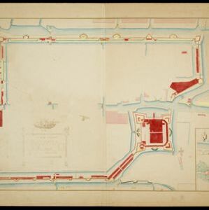
Plattegrondtekening der vestingwerken van de stad en 't kasteel Batavia
1898
Indonesia
Hand-drawn and coloured plan of the fortifications at Batavia (Jakarta, Java) including the castle, city walls, and moat and canal system. An inset map features four more of the city’s fortifications. This is a copy of an original 1788 map.
![](https://historicalmaps.yale-nus.edu.sg/rails/active_storage/representations/eyJfcmFpbHMiOnsibWVzc2FnZSI6IkJBaHBBY3M9IiwiZXhwIjpudWxsLCJwdXIiOiJibG9iX2lkIn19--230833c7ee81289c92f6093244601b1a513b82e9/eyJfcmFpbHMiOnsibWVzc2FnZSI6IkJBaDdCam9MY21WemFYcGxTU0lNTkRBd2VETXdNQVk2QmtWVSIsImV4cCI6bnVsbCwicHVyIjoidmFyaWF0aW9uIn19--bc467f5637e8b6d3bfb826116f92b6bfedfbf03a/leiden-2017185.jpeg)
Atlas van Nederlandsch Oost-Indië
c.1897-1904
Indonesia
Very detailed atlas of the entire Dutch East Indies, over 16 map sheets, with a cover and overview map. Includes topographic maps, inset maps of cities and islands, and maps featuring land and sea routes, languages, geology, colonial territory etc.
![](https://historicalmaps.yale-nus.edu.sg/rails/active_storage/representations/eyJfcmFpbHMiOnsibWVzc2FnZSI6IkJBaHBBa0lGIiwiZXhwIjpudWxsLCJwdXIiOiJibG9iX2lkIn19--05bfd0f8deb6dec23c74502c9135cca99c6db385/eyJfcmFpbHMiOnsibWVzc2FnZSI6IkJBaDdCam9MY21WemFYcGxTU0lNTkRBd2VETXdNQVk2QmtWVSIsImV4cCI6bnVsbCwicHVyIjoidmFyaWF0aW9uIn19--bc467f5637e8b6d3bfb826116f92b6bfedfbf03a/beinecke-15249793.jpeg)
Topographische kaart van het eiland Billiton: vluchtig opgenomen in de jaren 1877-1878
1894
Indonesia
This map of the island of Billiton (Belitung, Indonesia) features mountains, rivers, railways, roads, settlements, coconut plantations and administrative borders. An inset map shows the island’s port and capital city Tanjung Pandan.
- Dutch East Indies17
- Batavia16
- Jakarta16
- Java16
- Madura7
- Borneo4
- Ambon3
- Banda Islands3
- Belitung3
- Celebes3
- Chineesche Zee3
- Jakarta Bay3
- more Detailed Location »
- Kampong/Village15
- Residential Area15
- Hospital14
- Military Fort14
- Public Space13
- Cemetery/Columbarium11
- Church9
- Court of Law6
- Communal Land/Property4
- Military Barracks4
- Palace4
- Post Office4
- Well4
- Jail/Prison3
- more Settlement Features »
- Baarsel, Cornelis van2
- Baarsel, W.C. van2
- Bosch, J. van den2
- Derfelden van Hinderstein, Gijsbert Franco von2
- Keulen, Gerard van2
- Seijff, R.F. de2
- Staveren, J. van2
- Versteeg, W.F.2
- more Map Maker »
- Topographische Inrichting4
- Topographische Bureau3
- Gebroeders van Cleef2
- Homann Heirs2
- Robert Sayer2
- Th. Lejeune, Libraire Editeur2
- Departement van Koloniën1
- G. Kolff & Co.1
- more Printer/Publisher »
- The Hague9
- Batavia4
- Amsterdam3
- London3
- Brussels2
- Manila1
- New York1
- Nuremberg1
- more Place of Publication »