Search

Search Results

Vaarwaters en ankerplaatsen nabij het eiland Banka

event1898

location_onIndonesia

Four navigation maps of locations around Banka (Bangka) Island, east of Sumatra. Anchor points, lighthouses, bathymetry (sea depth), shoals and other obstructions and landmarks (hills, buildings, trees) are shown.

Straat Banka: Zuidblad

event1897

location_onIndonesia

Navigation map of the southern part of the Bangka Strait between Sumatra and Bangka Island. Bathymetry (sea depth), lighthouses, reefs, shoals and other obstructions (clay, coral, mud, stones, sand) are marked.

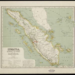
Soematra, Bangka en de Riouw-Lingga Archipel

event1897

location_onMalaysia, Indonesia, Singapore, Myanmar

Map of Sumatra and surrounding islands, with residencies—administrative districts—shown by coloured borders. There are inset maps of two residencies surrounding Padang, and of Groot-Atjeh (Aceh). Rivers, railways, roads and settlements are marked.

Sumatra, Bangka, Blitoeng en de Riouw-archipel

event1890

location_onIndonesia

This map of Sumatra is divided into administrative areas called ‘residencies’, which include the surrounding islands such as the Riau Archipelago and islands in the South China Sea.

Geognostisch-mijnbouwkundige kaart van het eiland Bangka, distrikt Blinjoe

event1872

location_onIndonesia

A geological map showing the types of rock and minerals found in Blinjoe district on the island of Bangka, off the east coast of Sumatra. Deposits of iron, quartz and tin are marked, and coral is shown at the coast.

close

  • Filter from 1872 to 1898

Current results range from 1872 to 1898