
Search Results
18 Results found


Algemeene kaart van Nederlandsch Oostindie
c.1839-1855
East Timor, Indonesia, Malaysia, Singapore
This map of the Dutch East Indies is spread over eight sheets, with a hand-drawn cover sheet showing the whole area. There are numerous inset maps of islands, bays, cities etc. Two of the inset maps have a replacement map pasted over them.

The continent and islands of Asia: with all the latest discoveries
1839
Brunei, Cambodia, East Timor, Indonesia, Laos, Malaysia, Myanmar, Papua New Guinea, Singapore, Philippines, Southeast Asia, Thailand, Vietnam
On this map of Asia, the South China Sea is labelled ‘Malayan Sea’. Small islands, shoals and reefs are shown. A label in Cochin China (Vietnam) reads ‘mountains inhabited by the uncivilized people called Kemoys’.

The continent and islands of Asia: with all the latest discoveries
1809
Vietnam, Myanmar, Papua New Guinea, Philippines, Singapore, Southeast Asia, Thailand, Malaysia, Laos, Indonesia, East Timor, Cambodia, Brunei
Southeast Asia is on the last sheet of this map of Asia. The South China Sea is labelled ‘Malayan Sea’. Small islands, shoals and reefs are shown. A label in Cochin China (Vietnam) reads ‘mountains inhabited by the uncivilized people called Kemoys’.

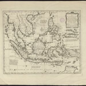
Nieuwe en Naukeurige Kaart der Oost-Indische Eilanden
1774
Brunei, Cambodia, East Timor, Indonesia, Laos, Malaysia, Myanmar, Philippines, Singapore, Southeast Asia, Thailand, Vietnam
Some regions on this map of Southeast have a descriptive label: New Guinea is described as unknown to Europeans; Borneo was abandoned by Europeans due to the ‘unmanageability’ of the inhabitants; the Philippines were discovered by Spain in 1565.
Nieuwe en naukeurige kaart der Oost-Indische Eilanden
c.1770
Brunei, Cambodia, East Timor, Indonesia, Laos, Malaysia, Myanmar, Philippines, Singapore, Southeast Asia, Thailand, Vietnam
Some regions on this map of Southeast have a descriptive label: Sumatra is described as having mines of gold, silver, iron, and sulphur; and elephants, tigers, rhinoceroses, dragons and crocodiles. Gilolo has rice, sago and turtles. Ambon has nutmeg.

Partie de la nouvelle grande carte des Indes Orientales, contenant les isles Maldives, Ceylan, Malacca, Sumatra... les isles de Borneo, Iava, Celebes, Mindanao
c.1750
Brunei, East Timor, Indonesia, Malaysia, Papua New Guinea, Philippines, Singapore
Map of maritime Southeast Asia, with mountains, forests and settlements represented pictorially. The lower part of the map, which had six inset maps, has been cut off and is missing.

Partie de la nouvelle grande carte des Indes Orientales, contenant les isles Maldives, Ceylan, Malacca, Sumatra... les isles de Borneo, Iava, Celebes, Mindanao
c.1750
Brunei, East Timor, Indonesia, Malaysia, Papua New Guinea, Philippines, Singapore
Map of maritime Southeast Asia, with four inset maps of locations in the region: Surabaya, some of the Lesser Sumba Islands, and Buton and Muna islands of the coast of Sulawesi. Mountains, forests, settlements and fields are represented pictorially.
- [remove]East Timor18
- [remove]Indonesia18
- Malaysia17
- Singapore17
- Brunei15
- Philippines15
- Cambodia13
- Laos13
- Myanmar13
- Southeast Asia13
- Thailand13
- Vietnam13
- more Simple Location »
- [remove]Jungle/Wooded Area18
- Mountain/Volcano18
- Wild Animals4
- Wetlands3


