
Search Results
Filter
Map Attributes
Scale
Remove constraint Map Attributes: Scale
Land Features
Mountain/Volcano
Remove constraint Land Features: Mountain/Volcano
Land Routes
Path
Remove constraint Land Routes: Path
Language
German
Remove constraint Language: German
Place of Publication
Gotha
Remove constraint Place of Publication: Gotha
2 Results found

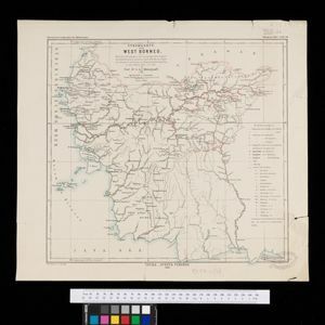
Stromkarte von West Borneo... mit Angabe der Stationen und Routen der Niederländischen Expedition in den Jahren 1893 und 1894
1895
Indonesia
The route of a late 19th century expedition by Dutch geologists, botanists, ethnographers and zoologists is marked on this map of southwest Borneo. Mountain peaks which were surveyed by the geologists are highlighted with a red circle.


