
Search Results
41 Results found


Algemeene kaart van Nederlandsch Indië
1879
Cambodia, Indonesia, Papua New Guinea, East Timor, Southeast Asia, Thailand, Malaysia, Philippines, Laos, Vietnam, Singapore, Brunei, Myanmar
A late 19th century map of the Dutch East Indies on four sheets, detailing maritime routes around the region. There are also inset maps showing railways, rivers, roads, and telegraph systems, as well as individual islands and cities.

Asien
1850
Brunei, Cambodia, East Timor, Indonesia, Laos, Malaysia, Myanmar, Singapore, Philippines, Southeast Asia, Thailand, Vietnam
This map of Asia uses hachures—short lines/dashes that give a sense of the shape and steepness of terrain—over most of Southeast Asia. Major rivers, islands and cities are also marked.

Asien
c.1850
Brunei, Cambodia, East Timor, Indonesia, Laos, Malaysia, Myanmar, Papua New Guinea, Philippines, Singapore, Southeast Asia, Thailand, Vietnam
On this map of Asia, colours are used to show the colonial territories of the European powers, and to show Muslim and Buddhist regions: Sumatra is divided between the Netherlands and local rulers; the Straits Settlements underlined in red (British).

Asien
1850
Brunei, Cambodia, East Timor, Indonesia, Laos, Malaysia, Myanmar, Singapore, Philippines, Southeast Asia, Thailand, Vietnam
This map of Asia uses hachures—short lines/dashes that give a sense of the shape and steepness of terrain—over most of Southeast Asia. Major rivers, islands and cities are also marked.
Asien
c.1850
Brunei, Cambodia, East Timor, Indonesia, Laos, Malaysia, Myanmar, Papua New Guinea, Philippines, Singapore, Southeast Asia, Thailand, Vietnam
On this map of Asia, colours are used to show the colonial territories of the European powers, and to show Muslim and Buddhist regions: Sumatra is divided between the Netherlands and local rulers; the Straits Settlements underlined in red (British).

Asia cum omnibus Imperiis, Provinciis, Statibus et Insulis correcta et adornata
1840
Brunei, Cambodia, East Timor, Indonesia, Laos, Malaysia, Myanmar, Papua New Guinea, Philippines, Singapore, Southeast Asia, Thailand, Vietnam
This colourful map of Asia has an elaborate cartouche featuring two Asian men talking—one carries a bow, the other smokes a long pipe—while a lion sits nearby. The scale is also illustrated, with drawings of Asian birds.
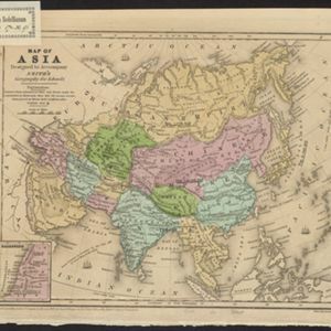
Map of Asia: Designed to accompanying Smith's Geography for Schools
1839
Brunei, Cambodia, Indonesia, Laos, Malaysia, Myanmar, Philippines, Singapore, Thailand, Vietnam, Southeast Asia
Map of Asia, marked with populations of cities and lengths of rivers. Mainland Southeast Asia is divided into kingdoms, but maritime Southeast Asia is mostly blank, and parts such as Java and the Lesser Sunda Islands are left off entirely.

Ost-Indien mit den Inseln
c.1835
Brunei, Cambodia, East Timor, Indonesia, Laos, Malaysia, Myanmar, Philippines, Singapore, Southeast Asia, Thailand, Vietnam
On this map of India and Southeast Asia, borders are outlined and cities underlined in different colours to show the colonial territories of the European powers. On Borneo, the names of indigenous peoples are listed (‘Dayak’s, Papua’s, Bugi’s’).
- Brunei41
- Cambodia41
- [remove]Indonesia41
- Laos41
- Malaysia41
- Myanmar41
- Philippines41
- Singapore41
- [remove]Southeast Asia41
- Thailand41
- Vietnam41
- East Timor37
- more Simple Location »


