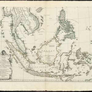
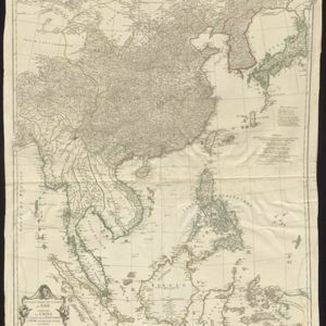
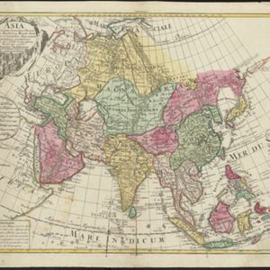
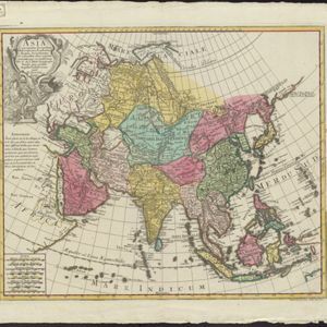
Search

Search Results

2e. carte de l'Asie

event1755

location_onBrunei, Cambodia, East Timor, Indonesia, Laos, Malaysia, Myanmar, Philippines, Singapore, Southeast Asia, Thailand, Vietnam

Mid-18th century French-language map of Asia, with Southeast Asia divided into four regions: the mainland in yellow, the Philippines in green, the Sunda Islands in red, and the Maluku Islands in yellow.

Seconde partie de la carte d'Asie: contenant la Chine et partie de la Tartarie, l'Inde au delà du Gange, les isles Sumatra, Java, Borneo, Moluques, Philippines et du Japon

event1752

location_onBrunei, Cambodia, East Timor, Indonesia, Laos, Malaysia, Myanmar, Vietnam, Thailand, Southeast Asia, Singapore, Philippines

Labels on this mid-18th century map of Southeast Asia describe various local peoples as ‘sauvage [savage]’, including the ‘Ke-Moy’ of the mountains along the border of Cochinchine (Vietnam) and Camboja (Cambodia), and the ‘Biayos’ of central Borneo.

Seconde partie de la carte d'Asie: contenant la Chine et partie de la Tartarie, l'Inde au delà du Gange, les isles Sumatra, Java, Borneo, Moluques, Philippines et du Japon

event1752

location_onVietnam, Myanmar, Malaysia, Philippines, Singapore, Southeast Asia, Thailand, Laos, Indonesia, East Timor, Cambodia, Brunei

Labels on this mid-18th century map of Southeast Asia describe various local peoples as ‘sauvage [savage]’, including the ‘Ke-Moy’ of the mountains along the border of Cochinchine (Vietnam) and Camboja (Cambodia), and the ‘Biayos’ of central Borneo.

Seconde partie de la carte d'Asie: contenant la Chine et partie de la Tartarie, l'Inde au delà du Gange, les isles Sumatra, Java, Borneo, Moluques, Philippines et du Japon

event1752

location_onBrunei, Cambodia, East Timor, Indonesia, Laos, Malaysia, Myanmar, Vietnam, Thailand, Southeast Asia, Singapore, Philippines

Labels on this mid-18th century map of Southeast Asia describe various local peoples as ‘sauvage [savage]’, including the ‘Ke-Moy’ of the mountains along the border of Cochinchine (Vietnam) and Camboja (Cambodia), and the ‘Biayos’ of central Borneo.

Archipel des Indes Orientales: qui comprend les Isles de la Sonde, Moluques et Philippines

event1750

location_onBrunei, Cambodia, East Timor, Indonesia, Malaysia, Philippines, Singapore, Southeast Asia, Thailand, Vietnam

This 18th century map of Southeast Asia by the French cartographer Gilles Robert de Vaugondy features the national borders of the Philippines in green, and of modern Indonesia in yellow. The Malay Peninsula and modern Cambodia and Vietnam are in red.

Asia Concinnata Secundum Observationes Academiæ Regalis Scientiarum et nonnullas alias, et juxta annotationes recentissimas

eventc.1750

location_onBrunei, Cambodia, East Timor, Indonesia, Laos, Malaysia, Myanmar, Philippines, Singapore, Southeast Asia, Thailand, Vietnam

This mid-18th century map of Asia features a note stating that there are new features on this map not seen on previous maps, and that this is not a mistake. The cartouche features a column of Asian people riding on horses and camels.

Asia Concinnata Secundum Observationes Academiæ Regalis Scientiarum et nonnullas alias, et juxta annotationes recentissimas

eventc.1750

location_onBrunei, Cambodia, East Timor, Indonesia, Malaysia, Laos, Myanmar, Philippines, Singapore, Southeast Asia, Thailand, Vietnam

This mid-18th century map of Asia features a note stating that there are new features on this map not seen on previous maps, and that this is not a mistake. The cartouche features a column of Asian people riding on horses and camels.

Asia Concinnata Secundum Observationes Academiæ Regalis Scientiarum et nonnullas alias, et juxta annotationes recentissimas

eventc.1750

location_onBrunei, Cambodia, East Timor, Indonesia, Laos, Malaysia, Myanmar, Philippines, Singapore, Southeast Asia, Thailand, Vietnam

This mid-18th century map of Asia features a note stating that there are new features on this map not seen on previous maps, and that this is not a mistake. The cartouche features a column of Asian people riding on horses and camels.

Asia Concinnata Secundum Observationes Academiæ Regalis Scientiarum et nonnullas alias, et juxta annotationes recentissimas

eventc.1750

location_onBrunei, Cambodia, East Timor, Indonesia, Malaysia, Laos, Myanmar, Philippines, Singapore, Southeast Asia, Thailand, Vietnam

This mid-18th century map of Asia features a note stating that there are new features on this map not seen on previous maps, and that this is not a mistake. The cartouche features a column of Asian people riding on horses and camels.

Partie de la nouvelle grande carte des Indes Orientales, contenant les isles Maldives, Ceylan, Malacca, Sumatra... les isles de Borneo, Iava, Celebes, Mindanao

eventc.1750

location_onBrunei, East Timor, Indonesia, Malaysia, Papua New Guinea, Philippines, Singapore

Map of maritime Southeast Asia, with mountains, forests and settlements represented pictorially. The lower part of the map, which had six inset maps, has been cut off and is missing.

close