
Search Results
286 Results found

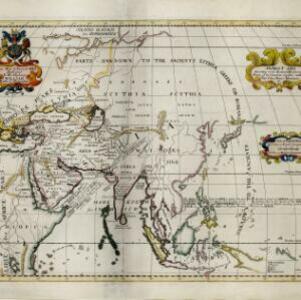
Ancient Asia according to its general divisions and names of its countries together with their chief cities, rivers, mountains &c.
1700
Brunei, Cambodia, East Timor, Indonesia, Laos, Malaysia, Myanmar, Philippines, Singapore, Southeast Asia, Thailand, Vietnam
Interestingly, this map from the year 1700 shows the world as the Greeks and Romans knew it. Therefore, Southeast Asia is labelled as 'PARTS UNKNOWN TO THE ANCIENTS' and lacks place names e.g. Sumatra is named ‘Taprobana I. according to some’.

[Portolan chart of the Gulf of Siam]
1697
Thailand, Vietnam, Malaysia, Cambodia
A brightly-coloured hand-drawn map of the Gulf of Siam, made for a ship’s captain. The elaborate compass roses are the centre of a rhumbline network, a web of lines to aid navigation. Bathymetry (sea depth), islands, shoals and reefs are also marked.

[Chart of the Indian Ocean]
1684
Cambodia, Indonesia, Malaysia, Myanmar, Thailand
Colourful hand-drawn portolan (nautical) navigation chart, featuring a rhumbline network (the web of interconnected lines), islands, shoals and reefs. With an elaborately decorated cartouche, scale and compass roses. Vellum on folding wood boards.

[Chart of the Indian Ocean]
1682
Cambodia, Indonesia, Malaysia, Myanmar, Singapore, Thailand
Colourful hand-drawn portolan (nautical) navigation chart, featuring a rhumbline network (the web of interconnected lines), islands, shoals and reefs. With elaborately decorated scales and compass roses. Mounted on folding wood boards.

Asia divided into its principall regions in which may be seen the extent of the Empires, Monarchies, Kingdoms and States which at present divide Asia
1680
Brunei, Cambodia, East Timor, Indonesia, Laos, Malaysia, Myanmar, Papua New Guinea, Philippines, Singapore, Southeast Asia, Thailand, Vietnam
This late 17th century map of Asia is by William Berry, based on an earlier map by the French cartographer Nicolas Sanson. Dedicated to King Charles II, it features the royal coat of arms of the United Kingdom in its elaborate cartouche.

A new plaine and exact map of Asia
1671
Brunei, Cambodia, East Timor, Indonesia, Laos, Malaysia, Myanmar, Philippines, Singapore, Southeast Asia, Thailand, Vietnam
This colourful map of Asia is illustrated with drawings of Asian people wearing traditional clothing, including a man and woman from Java in Southeast Asia, and drawings of important ports such as Bantan (Banten) situated at the western end of Java.


Exacta & accurata delineatio cum orarum maritimarum tum etiam locorum terrestrium quae in regionibus China, Cauchinchina, Camboia sive Champa, Syao, Malacca, Aracan & Pegu
1598
Brunei, Cambodia, East Timor, Indonesia, Laos, Malaysia, Myanmar, Philippines, Singapore, Southeast Asia, Thailand, Vietnam
Unusually, north is located to the left of this map of East Asia, rather than the top. The text notes that shallows and reefs are marked, and that the map is based on the explorations of Portuguese ships. Illustrations include sea monsters and ships.
- Filter from 1598 to 1900
- Myanmar172
- Thailand140
- Malaysia136
- Indonesia135
- Singapore109
- Vietnam109
- Cambodia100
- Laos96
- Philippines89
- Brunei83
- East Timor71
- Southeast Asia71
- more Simple Location »


