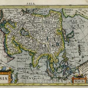
Search

Search Results

Asia

eventc.1609-1621

location_onBrunei, Cambodia, East Timor, Indonesia, Laos, Malaysia, Myanmar, Philippines, Singapore, Southeast Asia, Thailand, Vietnam

This early 17th century map of Asia by Jodocus Hondius was based on the earlier work of the Gerard Mercator. Hondius republished Mercator’s ‘Atlas’, with additional maps, which was instrumental in re-establishing Mercator’s reputation.

Charte von Ost-Indien und den angroentzenden Laendern

event1737

location_onBrunei, Cambodia, East Timor, Indonesia, Laos, Malaysia, Myanmar, Philippines, Singapore, Southeast Asia, Thailand, Vietnam

The London-based cartographer Herman Moll (1654?–1732) created this map of Asia in the early 18th century. There are five insets showing Asian trading cities, including of the ports of Batavia (Jakarta) and Bantam (Banten) in western Java.

Asia

event1826

location_onBrunei, East Timor, Cambodia, Indonesia, Laos, Malaysia, Myanmar, Papua New Guinea, Philippines, Singapore, Southeast Asia, Thailand, Vietnam

This map of Asia is from the earliest version of ‘Stielers Handatlas’ by the German cartographers Adolf Stieler and Christian Gottlieb Reichard. The maps were initially published separately; later editions compiled them into book form.

Die Ostindischen Inseln

event1830

location_onBrunei, Cambodia, East Timor, Indonesia, Laos, Malaysia, Myanmar, Philippines, Singapore, Southeast Asia, Thailand, Vietnam

Map of Southeast Asia highlighting European colonial possessions. Unusually, the south coast of the Philippine island of Mindanao is shown twice, reflecting uncertainty about its true location. Names of indigenous peoples are listed on Borneo.

Asien 1831

event1831

location_onBrunei, Cambodia, East Timor, Indonesia, Laos, Malaysia, Myanmar, Papua New Guinea, Philippines, Singapore, Southeast Asia, Thailand, Vietnam

On this map of Asia, borders are outlined and cities underlined in different colours to show the colonial territories of the European powers: Russian, British, Dutch, French, Spanish, Portuguese and Danish.

Ost-Indien mit den Inseln

event1831

location_onBrunei, Cambodia, East Timor, Indonesia, Laos, Malaysia, Myanmar, Philippines, Singapore, Southeast Asia, Thailand, Vietnam

On this map of India and Southeast Asia, borders are outlined and cities underlined in different colours to show the colonial territories of the European powers: British, Dutch, Spanish, Portuguese, French and Danish.

Ost-Indien mit den Inseln

eventc.1835

location_onBrunei, Cambodia, East Timor, Indonesia, Laos, Malaysia, Myanmar, Philippines, Singapore, Southeast Asia, Thailand, Vietnam

On this map of India and Southeast Asia, borders are outlined and cities underlined in different colours to show the colonial territories of the European powers. On Borneo, the names of indigenous peoples are listed (‘Dayak’s, Papua’s, Bugi’s’).

Hinter Indien nebst den Hinterindischen Inseln

event1836

location_onCambodia, East Timor, Indonesia, Laos, Malaysia, Myanmar, Brunei, Philippines, Singapore, Southeast Asia, Thailand, Vietnam

Coloured borders identify the colonial possessions of Britain, the Netherlands, Spain, Denmark and Portugal in mid-19th century Southeast Asia. Cities are marked with symbols indicating population, and military forts are marked with star symbols.

close

  • Filter from 1609 to 1890

Current results range from 1609 to 1890