
Search Results


Topographische kaart der residentie Besoeki
1888
Indonesia
The residency of Besoeki (Besuki), East Java, featuring crops (rice, alang-alang, bamboo, coconut); fishing ponds; factories, warehouses, businesses; routes, administrative borders; churches, cemeteries, forts, lighthouses; mountains, rivers, lakes.

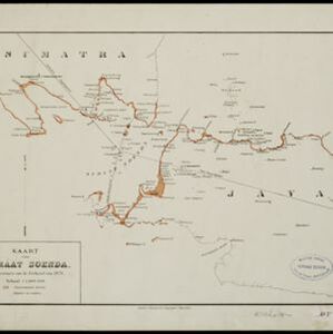
Topographische kaart der residentie Pasoeroean
1887
Indonesia
The residency of Pasoeroean (Pasuruan), East Java, featuring crops (coffee, cinchona (kina), rice, alang-alang, bamboo) and fishing ponds. Two inset maps: a triangulation map, and a map of distances between settlements by various types of transport.

Topographische kaart der residentie Madoera
c.1885-1887
Indonesia
Three-sheet topographic map of the residency of Madoera (Madura, East Java), with an inset map of distances between locations. Administrative districts, crops—bamboo, sugarcane, alang-alang, rice, coconut, betel—salt pans and fishing ponds are shown.

Topographische kaart der residentie Probolinggo
c.1884-1885
Indonesia
Four-sheet topographic map of the residency of Probolinggo (East Java), with an inset map of distances between locations by rail and road, and a signal map. Crops, fishing ponds, sugar factories, and coffee and salt warehouses are shown.


Topographische kaart der residentie Soerabaja
1884
Indonesia
The residency of Soerabaja, East Java, featuring crops (coffee, coconut, sugarcane, rice, alang-alang, bamboo) and fishing ponds. Three inset maps: a triangulation map; a map of distances between settlements by types of transport; Bawean Island.

Kaart aangevende 1°. de verdeeling van Java en Madura in gewesten en wat de gouvernements-residentiën betreft, ook in afdeelingen en districten
1884
Indonesia
This late 19th century map shows Java and Madura divided into regencies and departments, and further divided into districts. Government land used for growing coffee, businesses, agriculture, railways, postal routes and major roads are also shown.

Ontwerp drinkwaterleiding voor de stad Cheribon
1884
Indonesia
Hand-drawn map of the design of a drinking water pipeline for the city of Cheribon (Cirebon) on the northern coast of Java. Roads, rivers, rice paddies and other fields are shown. The written notes include the city’s population figures by ethnicity.

Overzichtskaart en bladwijzer der afdeeling Banjoewangi
1883
Indonesia
This overview map of Banjoewangi (Banyuwangi Regency, East Java) features mountains, rivers and the Bali Strait. Distances between settlements are marked along the roads, and there is a small inset map of the city of Banjoewangi.
- Indonesia306
- Malaysia153
- Brunei148
- Singapore148
- East Timor140
- Philippines138
- Thailand132
- Cambodia128
- Vietnam127
- Southeast Asia123
- Laos122
- Myanmar122
- more Simple Location »


