Search

Search Results

Insulæ Indiæ orientalis

event1632

location_onBrunei, Cambodia, East Timor, Indonesia, Laos, Malaysia, Myanmar, Philippines, Singapore, Southeast Asia, Thailand, Vietnam

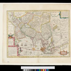
On this early 17th century map of maritime Southeast Asia, the southern coast of Java ('Iava Maior') is represented by a dotted line, indicating that the exact coastline was unknown at this time.

Asiæ Nova Descriptio Auctore Jodoco Hondio

event1630

location_onBrunei, Cambodia, East Timor, Indonesia, Laos, Malaysia, Myanmar, Philippines, Singapore, Southeast Asia, Thailand, Vietnam

An early 17th century map by the Flemish/Dutch cartographer Jodocus Hondius showing Asia and part of Europe and Africa. The Latin text on New Guinea translates as ‘Whether it is an island or the southern part of the continent is not yet certain’.

Asia: ex magna orbis terre descriptione Gerardi Mercatoris desumpta, studio & industria G.M. Iunioris

event1630

location_onBrunei, Cambodia, East Timor, Indonesia, Laos, Malaysia, Myanmar, Philippines, Singapore, Southeast Asia, Thailand, Vietnam

Originally published in Gerardus Mercator's ‘Atlas Sive Cosmographicae Meditationes de Fabrica Mundi et Fabricati Figura’ (1595), the title of which was the first use of the word ‘atlas’ to refer to a collection of maps. This is a 1630 reprint.

Insulæ Indiæ orientalis præcipuæ: in quibus Moluccæ celeberrimæ sunt

event1623

location_onBrunei, Cambodia, East Timor, Indonesia, Laos, Malaysia, Myanmar, Philippines, Singapore, Southeast Asia, Thailand, Vietnam

On the right of this map, Latin text held within an elaborate border notes that five of the Maluku Islands are located nearby—Ternate, Tidore, Moti, Makian and Bacan—which trade spices including clove, cinnamon, nutmeg and ginger to the world.

Moluccæ insulæ

event1618

location_onIndonesia, East Timor

Unusually, north is located to the right of this early 17th century map of the Maluku Islands, rather than the top. The scale is shown on a stone monument. French text on the reverse describes Java.

Asiæ Nova Descriptio Auctore Jodoco Hondio

eventc.1613-1619

location_onBrunei, Cambodia, East Timor, Indonesia, Laos, Malaysia, Myanmar, Philippines, Singapore, Southeast Asia, Thailand, Vietnam

An early 17th century map by the Flemish/Dutch cartographer Jodocus Hondius showing Asia and part of Europe and Africa. The Latin text on New Guinea translates as ‘Whether it is an island or the southern part of the continent is not yet certain’.

Asiæ Nova Descriptio Auctore Jodoco Hondio

eventc.1613-1616

location_onBrunei, Cambodia, East Timor, Indonesia, Laos, Malaysia, Myanmar, Philippines, Singapore, Southeast Asia, Thailand, Vietnam

An early 17th century map by the Flemish/Dutch cartographer Jodocus Hondius showing Asia and part of Europe and Africa. The Latin text on New Guinea translates as ‘Whether it is an island or the southern part of the continent is not yet certain’.

Insulæ Indiæ orientalis præcipuæ: in quibus Moluccæ celeberrimæ sunt

event1606

location_onBrunei, Cambodia, East Timor, Indonesia, Laos, Malaysia, Myanmar, Philippines, Singapore, Southeast Asia, Thailand, Vietnam

On the right of this map, Latin text held within an elaborate border notes that five of the Maluku Islands are located nearby—Ternate, Tidore, Moti, Makian and Bacan—which trade spices including clove, cinnamon, nutmeg and ginger to the world.

Exacta & accurata delineatio cum orarum maritimarum tum etiam locorum terrestrium quae in regionibus China, Cauchinchina, Camboia sive Champa, Syao, Malacca, Aracan & Pegu

event1598

location_onBrunei, Cambodia, East Timor, Indonesia, Laos, Malaysia, Myanmar, Philippines, Singapore, Southeast Asia, Thailand, Vietnam

Unusually, north is located to the left of this map of East Asia, rather than the top. The text notes that shallows and reefs are marked, and that the map is based on the explorations of Portuguese ships. Illustrations include sea monsters and ships.

Insvlae Molvccae

event1598

location_onBrunei, Cambodia, East Timor, Indonesia, Laos, Malaysia, Papua New Guinea, Philippines, Singapore, Southeast Asia, Thailand, Vietnam

A map featuring drawings of plants used to make spices in the Moluccas or Spice Islands: Nux Myristica (nutmeg), Cariophilorum arbor (cloves), Santalum flavum (yellow sandalwood), Santalum rubrum (red sandalwood), Santalum album (Indian sandalwood).

Exacta & accurata delineatio cùm orarum maritimarum tùm etiam locorum terrestrium quae in regionibus China, Cauchinchina, Camboia sive Champa, Syao, Malacca, Aracan & Pegu

event1596

location_onBrunei, Cambodia, East Timor, Indonesia, Laos, Malaysia, Myanmar, Philippines, Singapore, Southeast Asia, Thailand, Vietnam

Unusually, north is located to the left of this map of East Asia, rather than the top. The text notes that shallows and reefs are marked, and that the map is based on the explorations of Portuguese ships. Illustrations include sea monsters and ships.

close