
Search Results
Filter
Map Attributes
Scale
Remove constraint Map Attributes: Scale
Printer/Publisher
Institut National de Géographie
Remove constraint Printer/Publisher: Institut National de Géographie
Sea Routes
Bathymetry
Remove constraint Sea Routes: Bathymetry
Collections
Leiden University Libraries
Remove constraint Collections: Leiden University Libraries
4 Results found
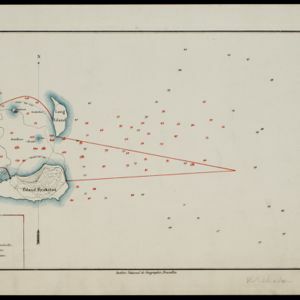


Kaart van Krakatau en omliggende eilanden
1883
Indonesia
A map of the effects of the 1883 Krakatoa volcanic eruption. The orange line is the islands’ outline pre-eruption; the red line is the boundary of the collapsed area. Red numbers are sea depth. Pre- and post-eruption sizes of the islands are listed.


