
Search Results


[Portolan chart of the South China Sea]
1679
Malaysia, Brunei, Cambodia, Thailand, Vietnam
A brightly-coloured hand-drawn map of the South China Sea. The compass is at the centre of a rhumbline network, a web of lines to aid navigation. Bathymetry (sea depth), islands, anchor points, shoals and reefs are also marked.

[Zuid-Chinese Zee]
1686
Indonesia, Malaysia, Thailand, Cambodia, Vietnam
Early navigation map of the South China Sea. The web of lines is a rhumbline network, while the numbers indicate sea depth (bathymetry), both used to aid navigation. A route around the Gulf of Thailand is marked with text and the dates 1643 and 1644.

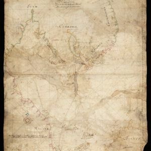
[Portolan chart of the Gulf of Siam]
1697
Thailand, Vietnam, Malaysia, Cambodia
A brightly-coloured hand-drawn map of the Gulf of Siam, made for a ship’s captain. The elaborate compass roses are the centre of a rhumbline network, a web of lines to aid navigation. Bathymetry (sea depth), islands, shoals and reefs are also marked.

[Dutch portolan chart of the island of Madura]
c.1700
Indonesia
Colourful hand-drawn portolan (nautical) navigation chart, featuring bathymetry (sea depth), shoals and reefs, and anchor points. The coasts have pictorial representations of landmarks (trees, houses, mountains). Orientated with south at the top.

[Dutch Portolan chart of the Java Sea]
c.1700
Indonesia
Hand-drawn portolan (nautical) chart, featuring a rhumbline network (the web of interconnected lines), bathymetry (sea depth), shoals and reefs, elevations (side views of landmark mountains), and names of coastal settlements, all to aid navigation.


[Portolan chart of the South China Sea]
1701
Brunei, Cambodia, Indonesia, Laos, Malaysia, Philippines, Thailand, Vietnam
Hand-drawn portolan (nautical) chart, featuring a rhumbline network (the web of interconnected lines), bathymetry (sea depth), shoals and reefs, names of coastal settlements, and an elevation (side view) of a mountain at the north tip of Borneo.


