
Search Results


Kaart van het gebied bezet in Groot-Atjèh
1898
Indonesia
A large-scale map of Groot-Atjceh, northern Sumatra, spread over six sheets, and featuring details such as routes, crops (rice, banana, sugarcane, alang-alang, bamboo), mountains and wetlands, and settlements (city of Kota Radja (modern Banda Aceh)).

Map of the Island of Singapore and its dependencies
1898
Singapore
Map of Singapore Island, divided into Districts, including the surrounding islands and straits. The city centre, roads and forests are marked. MacRitchie Reservoir is at the centre of the island, with coconut plantations along the east coast.


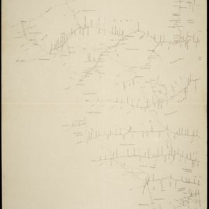
Kaart van het gebied bezet in Groot-Atjeh, met de nederzettingen Lepoeng en Lehoeng
1897
Indonesia
A map of Groot-Atjeh, Lepoeng and Lehoeng, at the northern tip of Sumatra, detailing routes (rivers, roads, railways), crops (rice, banana, sugarcane, betel, pepper, alang-alang, bamboo) and land features (forests, mountains, wetlands).


Voorontwerp eener spoorweghaven te Soerabaia
1897
Indonesia
Spread over four sheets, this is a detailed hand-drawn plan for railway and tramway lines at the port of Soerabaia (Surabaya, East Java). It includes a railway station, commercial areas, housing, customs, warehouses, offices and government buildings.

Expeditiën naar Bali in 1846, -48, -49 en -68
1897
Indonesia
Map of Bali, with five inset maps showing locations of Dutch military interventions on the island from 1846 to 1868. Troop positions and Balinese defences—barricades, moats—are marked, along with terrain, roads, palaces, temples and villages.
- Filter from 1600 to 1900
- [remove]Kampong/Village311
- Residential Area110
- Military Fort81
- Cemetery/Columbarium75
- Post Office65
- Church49
- Hospital47
- Temple46
- Military Barracks44
- Mosque36
- Public Space32
- Jail/Prison26
- Palace25
- Police Station21
- more Settlement Features »


