Search Results
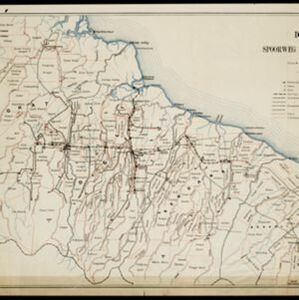
Topographische kaart van de residentie Preanger regentschappen
1894
Indonesia
The residency of Preanger (Parahyangan), West Java, with plantations (coconut, coffee, tea, cinchona (‘kina’), betel, teakwood, bamboo) and crops (rice, sugarcane, alang-alang). Two inset maps: a triangulation map, and a map of land route distances.
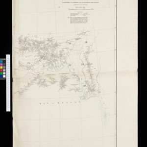
Index to relative positions of gold mining & prospecting grants: District Katha
1893
Myanmar
Map of the Katha district, Burma (Myanmar), with locations of gold mines and land allocated for prospecting. High points are marked and linked with lines to create a triangulation network. The Mu Valley State Railway and Mu River are shown.
- Dutch East Indies44
- Java28
- Sumatra19
- Soerabaja9
- Surabaya9
- Aceh6
- Banda Aceh6
- Upper Burma6
- Batavia5
- Jakarta5
- Lower Burma5
- Madura5
- more Detailed Location »
- Kampong/Village31
- Residential Area26
- Cemetery/Columbarium16
- Military Barracks14
- Post Office14
- Hospital12
- Military Fort12
- Church10
- Temple10
- Mosque9
- Police Station9
- Public Space9
- Jail/Prison8
- Palace7
- more Settlement Features »
- [remove]Railway Station56
- Port13
- Pier3
- [remove]Scale56
- Longitude and Latitude40
- Contour Lines/Elevation29
- Written Note/Details22
- Compass Rose2
- Stemfoort, J.W.2
- Thuillier, Colonel H.R.2
- Anderson, W.1
- Bakhuis, Louis August1
- Calmeyer, J.H.1
- Cronenberg, G.P.F.1
- Donnadieu1
- Eckstein, Charles1
- more Map Maker »
- Topographische Bureau19
- Topographische Inrichting8
- Survey of India Offices, Calcutta7
- Seyffardt's Boekhandel3
- J.H. de Bussy2
- Jos. Smulders & Co.2
- A.J. Jopp1
- De Groot, Kolff en Co.1
- more Printer/Publisher »
- Batavia22
- The Hague10
- Amsterdam5
- Dehradun3
- Surabaya3
- Bandung1
- Edinburgh1
- Leiden1
- more Place of Publication »