
Search Results


Western part of the Java Sea : from Lucipara I. to Sunda Strait and Batavia
1866
Indonesia
Designed to aid navigation around the western Java Sea, this map features bathymetry (sea depth), current and tide data, and is marked with shoals, reefs and other hazards. Written notes add details at specific locations (e.g. ‘heavy tide rips’).

Nederlandsch Oost-Indië
1865
Brunei, Cambodia, East Timor, Indonesia, Laos, Malaysia, Myanmar, Vietnam, Thailand, Southeast Asia, Singapore, Philippines, Papua New Guinea
This detailed map of the Dutch East Indies in the mid-19th century contains a great deal of information: topographical details, settlements and administrative areas, roads, railways and maritime routes, telegraph lines, inset maps etc.


Algemeene kaart van Nederlandsch Oostindie
c.1839-1855
East Timor, Indonesia, Malaysia, Singapore
This map of the Dutch East Indies is spread over eight sheets, with a hand-drawn cover sheet showing the whole area. There are numerous inset maps of islands, bays, cities etc. Two of the inset maps have a replacement map pasted over them.

A new chart of the straits of Sunda: From the manuscript of the Dutch East India Company
1794
Indonesia
Navigation chart of the Sunda Strait, showing bathymetry (sea depth), shoals and reefs, landmarks, and a rhumbline network. Notes record good anchorages, sources of water and supplies etc. Inset map of the Zutphen Islands off the coast of Sumatra.
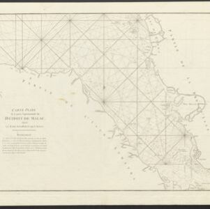
Carte Plate de la Partie Septentrionale du Détroit de Malac: depuis la Rade D'Áchem jusqu'a Malac
1775
Indonesia, Malaysia
Map of the northern Malacca Strait—between Sumatra and Malaya—with shoals and reefs marked, some labelled as ‘dangerous’. The web of lines is a rhumbline network, while the numbers indicate sea depth (bathymetry), both used to aid navigation.

Nieuwe en Naukeurige Kaart der Oost-Indische Eilanden
1774
Brunei, Cambodia, East Timor, Indonesia, Laos, Malaysia, Myanmar, Philippines, Singapore, Southeast Asia, Thailand, Vietnam
Some regions on this map of Southeast have a descriptive label: New Guinea is described as unknown to Europeans; Borneo was abandoned by Europeans due to the ‘unmanageability’ of the inhabitants; the Philippines were discovered by Spain in 1565.

Nieuwe en naukeurige kaart der Oost-Indische Eilanden
c.1770
Brunei, Cambodia, East Timor, Indonesia, Laos, Malaysia, Myanmar, Philippines, Singapore, Southeast Asia, Thailand, Vietnam
Some regions on this map of Southeast have a descriptive label: Sumatra is described as having mines of gold, silver, iron, and sulphur; and elephants, tigers, rhinoceroses, dragons and crocodiles. Gilolo has rice, sago and turtles. Ambon has nutmeg.
- Filter from 1595 to 1897
- [remove]Compass Rose64
- [remove]Written Note/Details64
- Longitude and Latitude59
- Scale50
- Rhumbline Network24
- Contour Lines/Elevation5


