
Search Results


Atlas van Nederlandsch Oost-Indië
c.1897-1904
Indonesia
Very detailed atlas of the entire Dutch East Indies, over 16 map sheets, with a cover and overview map. Includes topographic maps, inset maps of cities and islands, and maps featuring land and sea routes, languages, geology, colonial territory etc.


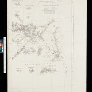
Overzichtskaart der residentie Wester-afdeeling van Borneo
1896
Indonesia
Map of western Borneo, divided into administrative districts. Mountains and larger settlements are marked with their height. A flag indicates a military garrison. A list of the districts notes their type of local ruler (Sultan, Prince etc.).

Kaart van den Nederlandsch Oost Indischen archipel aantoonende de door de Inlandsche bevolking beleden godsdiensten
1896
Indonesia
A map of the religions of the local peoples of the Dutch East Indies, with areas marked as Christian, Muslim, ‘heathen’. With population figures, including for Protestants and Catholics, and locations of missionaries and other religious teachers.

Kaart van de residentie Oostkust van Sumatra
1896
Indonesia
Detailed topographical map of the east coast of Sumatra, spread over 36 sheets. The area’s farms are listed and shown on the map within yellow borders, with types of crop grown. There is a detailed plan of Medan, and five inset maps of other towns.


- Filter from 1478 to 1900
- Indonesia270
- Malaysia184
- Myanmar183
- Thailand165
- Singapore164
- Vietnam152
- Cambodia147
- Philippines145
- Laos142
- Brunei141
- East Timor132
- Southeast Asia130
- more Simple Location »
- Legend129
- Cartouche106
- Illustration104
- Inset Map89
- Elevation42
- Coat of Arms24
- [remove]Longitude and Latitude329
- [remove]Written Note/Details329
- Scale231
- Contour Lines/Elevation122
- Compass Rose93
- Rhumbline Network29


