
Search Results


Les Indes orientales et leur archipel
1785
Brunei, Cambodia, East Timor, Indonesia, Laos, Malaysia, Myanmar, Philippines, Singapore, Southeast Asia, Thailand, Vietnam
A piece of paper printed with a list of the various regions of Asia, including the regions of Southeast Asia, has been adhered to the right-hand side of this late 18th century map of Asia.

Plan de Salangor et de La Cote de Malaye: depuis la Pointe de Caran jusqu'au Mont Parcelar
1775
Malaysia
Map of the coast of Selangor on the west of the Malay Peninsula. The web of lines is a rhumbline network, the numbers indicate sea depth (bathymetry), and there are drawings of the side views of mountains (elevations), all to aid navigation.

L'Asie Divisée en ses Grandes Régions et Empires: Subdivisée en ses Principaux Estats
1759
Brunei, Cambodia, East Timor, Indonesia, Laos, Malaysia, Myanmar, Philippines, Singapore, Southeast Asia, Thailand, Vietnam
Map of the regions, empires and states of Asia. Extensive notes cover religion (people of mainland Southeast Asia are idolaters), colonialism (Dutch and Portuguese rule in Malacca and the Sunda Islands) and the spice trade of the Maluku Islands.
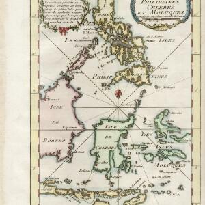
Carte des isles Philippines, Celebes et Moluques
c.1746-1770
Brunei, Malaysia, Philippines, Indonesia, East Timor
The note in French at the top left of this map states that although the map is accurate, the names of many small islands have been omitted to avoid confusion, and that more details will come later.

Carte des Indes, de la Chine & des Iles de Sumatra, Java &c.
1719
Brunei, Cambodia, East Timor, Indonesia, Laos, Malaysia, Myanmar, Philippines, Singapore, Southeast Asia, Thailand, Vietnam
Text on this map notes that Sumatra is divided into two equal parts by the Equator, so that the days and nights are always the same length. It also notes that Java is ruled by the Dutch, though the Mataram Sultanate in central Java is also mentioned.

Les isles Philippines et celles des Larrons ou de Marianes, les isles Moluques et de la Sonde, avec la presqu'isle de l'Inde de la le Gange ou orientale
1706
Brunei, Cambodia, East Timor, Indonesia, Laos, Malaysia, Myanmar, Philippines, Singapore, Southeast Asia, Thailand, Vietnam
This early 18th century map of Southeast Asia includes a list detailing the location (latitude and longitude) of seven important cities in the region: Batavia, Achem, Camboya, Siam, Borneo, Macaçar and Manilla.

Les isles Philippines et celles des Larrons ou de Marianes, les isles Moluques et de la Sonde, avec la presqu'isle de l'Inde de la le Gange ou orientale
1705
Brunei, Cambodia, East Timor, Indonesia, Laos, Malaysia, Myanmar, Philippines, Singapore, Southeast Asia, Thailand, Vietnam
This early 18th century map of Southeast Asia includes a list detailing the location (latitude and longitude) of seven important cities in the region: Batavia, Achem, Camboya, Siam, Borneo, Macaçar and Manilla.

Les vrays Indes dits Grands Indes ou Indes Orientales
1705
Cambodia, Indonesia, Laos, Malaysia, Myanmar, Singapore, Thailand, Vietnam
Notes on the back of this map describe the kingdoms of mainland Southeast Asia: religion (people are idolaters, a few Christians and Jews, many Muslims), royalty (kings are rich, people are unhappy) and geography (rivers render the lands fertile).
- [remove]Scale12
- [remove]Written Note/Details12
- Longitude and Latitude8
- Compass Rose7
- Rhumbline Network2
- Contour Lines/Elevation1


