
Search Results


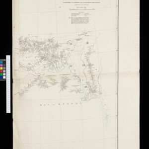
Plannen van ankerplaatsen Kleine Soenda eilanden
1893
Indonesia
Fifty-seven separate maps of bays, roadsteads—a body of water sheltered from tides/currents—and anchor points around the Lesser Sunda Islands. Landmarks, lighthouses, bathymetry (sea depth), shoals, reefs and other obstructions are marked.


Map to illustrate the Siamese question: showing the present limits of French claims, and the additional territory now demanded
1893
Cambodia, Laos, Malaysia, Myanmar, Thailand, Vietnam
Map highlighting areas of eastern Siam (Thailand) claimed by France. Notes describe Siam’s geography, government, population, military and trade (rice, teak, pepper, bullocks, fish, hides, tin, cardamom, tin), including trading partners by tonnage.

No. 4 preliminary chart of the principal triangulation of the Mandalay meridional series
1893
Myanmar
A triangulation map of part of Upper Burma (Myanmar), showing nine locations (‘hill stations’) joined with straight lines to create a triangulation network. Each hill station’s latitude and longitude, height above sea level, and description is given.

Kaart van de dichtheid van bevolking van Java en Madoera
1892
Indonesia
This map shows the population density of Java and Madura in 1892. The area is divided into regencies, which are then subdivided into districts, with the districts shaded to represent its population. Each district is also listed under its regency.

Kaart van den op Java en Madoera reeds in gebruik genomen grond
1892
Indonesia
Land usage statistics are shown on this map of Java and Madura. The amount of land used in each district is indicated by green hash marks, and by a number giving its land use percentage. District names are listed and identified by a letter.


- Filter from 1535 to 1900
- [remove]Scale267
- [remove]Written Note/Details267
- Longitude and Latitude231
- Contour Lines/Elevation123
- Compass Rose78
- Rhumbline Network26


