
Search Results


Carte d'Asie: dressée sur les memoires envoyéz par le Czar a l'Academie Royale des Science
c.1750
Brunei, Cambodia, East Timor, Indonesia, Laos, Malaysia, Myanmar, Philippines, Singapore, Southeast Asia, Thailand, Vietnam
An early 18th century map of Asia by the French cartographer Guillaume Delisle (1675–1726). Regions are indicated with coloured borders, and the southern part of Borneo is labelled ‘Côte de Mahometans [Coast of the Muslims]’.
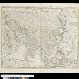
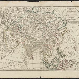
Carte d'Asie: dressée sur les memoires envoyéz par le Czar a l'Academie Royale des Science
1745
Brunei, Cambodia, East Timor, Indonesia, Laos, Malaysia, Myanmar, Philippines, Singapore, Southeast Asia, Thailand, Vietnam
An early 18th century map of Asia by the French cartographer Guillaume Delisle (1675–1726). Regions are indicated with coloured borders, and the southern part of Borneo is labelled ‘Côte de Mahometans [Coast of the Muslims]’.

Mapa de las Yslas Philipinas
1744
Indonesia, Philippines
First published in 1734, and commonly known as the ‘Velarde map’, this map by the Spanish cartographer Pedro Murillo Velarde is regarded as the first important map of the Philippines. This is a later version, lacking 12 drawings on the map's sides.
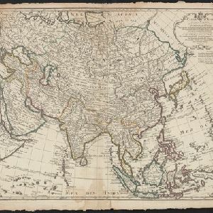
Carte d'Asie: dressée sur les memoires envoyéz par le Czar a l'Academie Royale des Science
1723
Brunei, Cambodia, East Timor, Indonesia, Laos, Malaysia, Myanmar, Singapore, Philippines, Southeast Asia, Thailand, Vietnam
An early 18th century map of Asia by the French cartographer Guillaume Delisle (1675–1726). Regions are indicated with coloured borders, and the southern part of Borneo is labelled ‘Côte de Mahometans [Coast of the Muslims]’.
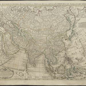
Carte d'Asie: dressée sur les memoires envoyéz par le Czar a l'Academie Royale des Science
c.1722-1774
Brunei, Cambodia, East Timor, Indonesia, Laos, Malaysia, Myanmar, Philippines, Singapore, Southeast Asia, Thailand, Vietnam
An early 18th century map of Asia by the French cartographer Guillaume Delisle (1675–1726). Regions are indicated with coloured borders, and the southern part of Borneo is labelled ‘Côte de Mahometans [Coast of the Muslims]’.
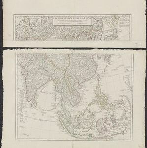
Carte des Indes et de la Chine
1705
Brunei, Cambodia, East Timor, Indonesia, Laos, Malaysia, Myanmar, Philippines, Southeast Asia, Singapore, Thailand, Vietnam
An early 18th century map of Asia by the French cartographer Guillaume Delisle (1675–1726). Regions are indicated with coloured borders, and the southern part of Borneo is labelled ‘Côte de Mahometans [Coast of the Muslims]’.

India quae Orientalis dicitur, et insvlae adiacentes
1664
Brunei, Cambodia, East Timor, Indonesia, Laos, Malaysia, Myanmar, Philippines, Singapore, Southeast Asia, Thailand, Vietnam
French text on the reverse of this map describes the religion, languages, crops, trade etc. of Aracam and Pegu (Myanmar), Siam (Thailand), Cambaja (Cambodia). The map is dedicated to the Dutch merchant Christophoro Thisio.

Molvccae insvlae celeberrimae
c.1640-1655
Indonesia
This small island chain off the west coast of Gilolo (Halmahera in the Maluku Islands, Indonesia), was an important area for the spice trade. Latin text on the reverse describes the trade/islands. North is located to the right, rather than the top.
- [remove]Religious Groups15
- Languages Spoken2
- Population Density2
- Race/Ethnicity1
- [remove]Written Note/Details15
- Longitude and Latitude14
- Scale6
- Compass Rose5
- Rhumbline Network2
- Contour Lines/Elevation1


