
Search Results
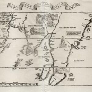
Tabv moder Indiae
1535
Cambodia, Indonesia, Malaysia, Myanmar, Thailand, Vietnam
Early map of Asia, with the islands of Taprobana (Sumatra) to the west of the Malay Peninsula, and Timonia (Tioman) to the east. Text gives details of local economies: sandalwood on Tioman, and silver and silk at Lamai near Mallaqua (Malacca).
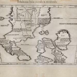
Tabula noua Indiæ orientalis & meridionalis
1541
Malaysia, Indonesia, Southeast Asia
This early map of Asia includes text describing the local people, their religious beliefs, crops, spices etc. On the island labelled Angama there is a drawing of anthropophagi—members of a mythical race of cannibals—chopping up a human body.

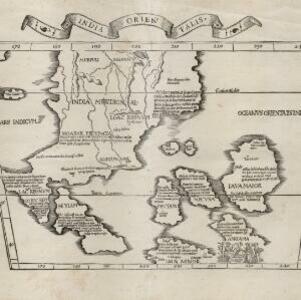
Tabvla Asiae XI
1561
Cambodia, Indonesia, Malaysia, Laos, Myanmar, Singapore, Thailand, Vietnam, Southeast Asia
Mid-16th century map by Girolamo Ruscelli, based on the work of 2nd century geographer Ptolemy. It is difficult to pinpoint exact locations, but the Malay Peninsula is recognisable. Italian text on the reverse describes the region.

Tabvla Asiae XI
1574
Cambodia, Indonesia, Malaysia, Laos, Myanmar, Singapore, Thailand, Vietnam, Southeast Asia
Mid-16th century map by Girolamo Ruscelli, based on the work of 2nd century geographer Ptolemy. It is difficult to pinpoint exact locations, but the Malay Peninsula is recognisable. Italian text on the reverse describes the region.

Indiae Orientalis insularumque adiacientium typus
1579
Brunei, Cambodia, East Timor, Indonesia, Laos, Malaysia, Myanmar, Philippines, Singapore, Southeast Asia, Thailand, Vietnam
A red banner at the right features text that notes that the ‘Insule Molucce’ (Maluku Islands) are famous for their abundance of spices, which are sold across the world. There are also Illustrations of mermaids and sea monsters wrecking a ship.

Indiae Orientalis insularumque adiacientium typus
1598
Brunei, Cambodia, East Timor, Indonesia, Laos, Malaysia, Myanmar, Philippines, Singapore, Southeast Asia, Thailand, Vietnam
A white banner at the right features text that notes that the ‘Insule Molucce’ (Maluku Islands) are famous for their abundance of spices, which are sold across the world. There are also Illustrations of mermaids and sea monsters wrecking a ship.

Insvlae Molvccae
1598
Brunei, Cambodia, East Timor, Indonesia, Laos, Malaysia, Papua New Guinea, Philippines, Singapore, Southeast Asia, Thailand, Vietnam
A map featuring drawings of plants used to make spices in the Moluccas or Spice Islands: Nux Myristica (nutmeg), Cariophilorum arbor (cloves), Santalum flavum (yellow sandalwood), Santalum rubrum (red sandalwood), Santalum album (Indian sandalwood).

Descriptio Malaccae
c.1600-1699
Malaysia, Singapore, Indonesia
Latin text on the reverse of this map describes Malacca, including crops and products (rice, pepper, spices, pearls), precious metals (gold, silver and tin), and animals (sheep, elephant), showing the city’s importance to European trade at the time.

India orien
1600
Brunei, Cambodia, East Timor, Indonesia, Laos, Malaysia, Myanmar, Philippines, Singapore, Southeast Asia, Thailand, Vietnam
Early 17th century map of Asia, with annotations in Latin naming the major countries, islands and cities. Maritime Southeast Asia is shown as an archipelago of many small islands. French text on the reverse describes crops and animals of the region.

Svmatra cum circumiacentibus insulis
1601
Indonesia, Malaysia, Singapore
A colourful early 17th century map of Sumatra, Java and the Malay Peninsula, with North located to the left, and major settlements marked. Latin text on the reverse describes the peoples, religions, languages, agriculture, mining etc. of the region.

- Filter from 1535 to 1728
- [remove]Written Note/Details31
- Longitude and Latitude27
- Scale20
- Compass Rose16
- Rhumbline Network10


