Search Results

Carte de l'ile de Java: partie occidentale, partie orientale, dressée tout nouvellement sur les mémoires les plus exacts
1726
Indonesia
The mountains and forests of early 18th century Java are beautifully illustrated here by the Dutch cartographer Henry Abraham Chatelain (1648-1743). Details include cities, fields of crops, animals and people. An inset map shows the port of Batavia.

Carte de l'ile de Java: partie occidentale, partie orientale, dressée tout nouvellement sur les mémoires les plus exacts
1720
Indonesia
The mountains and forests of early 18th century Java are beautifully illustrated here by the Dutch cartographer Henry Abraham Chatelain (1648-1743). Details include cities, fields of crops, animals and people. An inset map shows the port of Batavia.

Carte de l'ile de Java: partie occidentale, partie orientale, dressée tout nouvellement sur les mémoires les plus exacts
1719
Indonesia
The mountains and forests of early 18th century Java are beautifully illustrated here by the Dutch cartographer Henry Abraham Chatelain (1648-1743). Details include cities, fields of crops, animals and people. An inset map shows the port of Batavia.
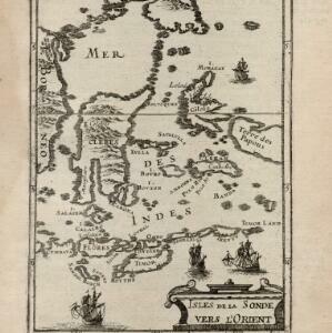
Isles de la Sonde vers l'Orient
1683
East Timor, Indonesia, Philippines
French text on the reverse of this map of the eastern Sunda Islands describes the city of Macassar (modern Makassar) on Celebes (Sulawesi, Indonesia). Details include the city’s port, trade and crops, as well as its people and religion.
- Filter from 1581 to 1845
- [remove]Plantation/Forestry Area12
- Crops11
- Domesticated Animals6
- Mining6
- [remove]Written Note/Details12
- Longitude and Latitude10
- Scale10
- Compass Rose4
- Contour Lines/Elevation4
- Rhumbline Network1

