Search

Search Results

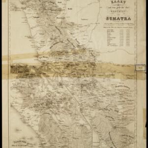
Kaart van een gedeelte der Westkust van Sumatra

event1855

location_onIndonesia

Hachures—short lines/dashes that give a sense of the shape and steepness of terrain—are used to show the mountains of Sumatra’s west coast, and of the Padang Highlands and Lowlands. Text lists the heights of some of the region’s chief mountains.

Carte d'Asie divisée en ses principaux etats

event1776

location_onMyanmar, Papua New Guinea, Philippines, Singapore, Southeast Asia, Thailand, Vietnam, Malaysia, Laos, Indonesia, East Timor, Cambodia, Brunei

The 20 colourful illustrations around the border of this 18th century map of Asia depict a variety of historical and biblical scenes, including the Crucifixion of Jesus and the sacking of Troy. Each scene has a description in French and Spanish.

Nova Totius Asiae Tabula

eventc.1750

location_onBrunei, Cambodia, East Timor, Indonesia, Laos, Malaysia, Myanmar, Philippines, Singapore, Southeast Asia, Thailand, Vietnam

This elaborately illustrated map of Asia is decorated with images of angels and cherubs, various figures dressed in colourful robes, wild animals, a procession including elephants and camels, and a double hemisphere world map.

To the Right Honourable William, Lord Cowper, Lord High Chancellor of Great Britain, this map of Asia

event1720

location_onBrunei, Cambodia, East Timor, Indonesia, Laos, Malaysia, Myanmar, Papua New Guinea, Philippines, Singapore, Southeast Asia, Thailand, Vietnam

Map dedicated to William Cowper, whose coat of arms sits atop the cartouche. It features two horses holding a crest with three martlets (mythical birds used in heraldry). The cartouche also features Asian traders. Monsoons are marked on the map.

A map of the East-Indies and the adjacent countries: with the settlements, factories and territories, explaning what belongs to England, Spain, France, Holland, Denmark, Portugal &c.

eventc.1720

location_onBrunei, Cambodia, East Timor, Indonesia, Laos, Malaysia, Myanmar, Philippines, Singapore, Southeast Asia, Thailand, Vietnam

This map showcases the colonial territories of Southeast Asia in the 18th century, with text detailing trading information and the products of each region. There are five inset maps featuring plans of specific trading ports.

A map of the East-Indies and the adjacent countries: with the settlements, factories and territories, explaning what belongs to England, Spain, France, Holland, Denmark, Portugal &c.

event1720

location_onBrunei, Cambodia, East Timor, Indonesia, Laos, Malaysia, Myanmar, Philippines, Vietnam, Thailand, Southeast Asia, Singapore

This map showcases the colonial territories of Southeast Asia in the 18th century, with text detailing trading information and the products of each region. There are five inset maps featuring plans of specific trading ports.

A map of the East-Indies and the adjacent countries: with the settlements, factories and territories, explaining what belongs to England, Spain, France, Holland, Denmark, Portugal &c.

event1717

location_onBrunei, Cambodia, East Timor, Indonesia, Laos, Malaysia, Myanmar, Philippines, Singapore, Southeast Asia, Thailand, Vietnam

This map showcases the colonial territories of Southeast Asia in the 18th century, with text detailing trading information and the products of each region. There are five inset maps featuring plans of specific trading ports.

To the Right Honourable William, Lord Cowper, Lord High Chancellor of Great Britain, this map of Asia

eventc.1715

location_onVietnam, Myanmar, Papua New Guinea, Philippines, Singapore, Southeast Asia, Thailand, Malaysia, Laos, Indonesia, East Timor, Cambodia, Brunei

The arrows on this map show the direction of the seasonal monsoons: each arrow has a label, indicating the month. The northeast coast of Borneo is labelled ‘A Desart [desert/deserted?] Coast’, while the south is labelled ‘Pepper Country’.

To the Right Honourable William, Lord Cowper, Lord High Chancellor of Great Britain, this map of Asia

event1715

location_onVietnam, Myanmar, Papua New Guinea, Philippines, Singapore, Southeast Asia, Thailand, Malaysia, Laos, Indonesia, East Timor, Cambodia, Brunei

This map is dedicated to William Cowper, whose coat of arms sits atop the cartouche. It features two horses holding a crest with three red martlets (mythical birds used in heraldry). The colourful cartouche also features Asian traders.

Isole dell'Indie divise in Filippine, Molucche e della Sonda

event1680

location_onBrunei, Cambodia, East Timor, Indonesia, Malaysia, Laos, Myanmar, Philippines, Singapore, Southeast Asia, Thailand, Vietnam

Dotted lines and colours divide maritime Southeast Asia into three regions on this map: the Philippine archipelago, Maluku Islands and Sunda Islands. The cartouche features cherub mermaids, and a map of mainland Southeast Asia is on the reverse.

Molvccae insvlae celeberrimae

eventc.1640-1655

location_onIndonesia

This small island chain off the west coast of Gilolo (Halmahera in the Maluku Islands, Indonesia), was an important area for the spice trade. Latin text on the reverse describes the trade/islands. North is located to the right, rather than the top.

close