
Search Results


Midden-Sumatra: Reizen en onderzoekingen der Sumatra-expeditie... 1877-1879
1882
Indonesia
An Atlas produced by an expedition in central Sumatra, including: maps of topography, geology, a number of rivers in the region; drawings of mountains, graphs of lengths of roads; family trees of the royal families of Djambi (Jambi) and Palembang.


Arracan: chart of the entrance to the river
1858
Myanmar
This navigation map of the mouth of the Kaladan River on the west coast of Arracan (modern Myanmar) features drawings of coastal features (elevations), bathymetry (sea depth), shoals and reefs, landmarks, and notes on how to enter the river safely.


Algemeene kaart van Nederlandsch Oostindie
c.1839-1855
East Timor, Indonesia, Malaysia, Singapore
This map of the Dutch East Indies is spread over eight sheets, with a hand-drawn cover sheet showing the whole area. There are numerous inset maps of islands, bays, cities etc. Two of the inset maps have a replacement map pasted over them.
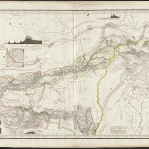
Karte von Assam: und seinen Nachbar-Ländern
1834
-
Map of Assam, including India’s border with northwest Birma (Myanmar) where indigenous lands/peoples are marked (Singphos, Naga, Kasi-Schan, Thai-Lung) e.g. ‘These mountainous landscapes are inhabited by the Naga tribes [translation from map text]’.

Royaume de Siam, avec les Royaumes qui luy sont Tributaires, et les Isles de Sumatra, Andemaon etc.
1742
Brunei, Cambodia, Indonesia, Laos, Malaysia, Myanmar, Singapore, Thailand, Vietnam
Map marking the routes through maritime Southeast Asia of two delegations: a French delegation from Brest, France to Siam in 1685; and a Siamese delegation from Siam to Brest in 1686. A note next to Aceh records a sea battle against Portugal in 1616.


- Longitude and Latitude14
- [remove]Written Note/Details14
- Scale12
- Compass Rose9
- Contour Lines/Elevation7
- Rhumbline Network5


