
Search Results
4 Results found


Algemeene kaart van Nederlandsch Oostindie
c.1839-1855
East Timor, Indonesia, Malaysia, Singapore
This map of the Dutch East Indies is spread over eight sheets, with a hand-drawn cover sheet showing the whole area. There are numerous inset maps of islands, bays, cities etc. Two of the inset maps have a replacement map pasted over them.
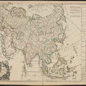
L'Asie suivant les dernres. observons. des Moscovites
1747
Brunei, Cambodia, East Timor, Indonesia, Laos, Malaysia, Myanmar, Philippines, Singapore, Southeast Asia, Thailand, Vietnam
The title of this mid-18th century map translates as ‘Asia following the latest observations of the Muscovites/Russians’. Written notes in French list the regions, islands, empires, kingdoms, colonial possessions, religions and languages of Asia.

A map of the East-Indies and the adjacent countries: with the settlements, factories and territories, explaning what belongs to England, Spain, France, Holland, Denmark, Portugal &c.
1720
Brunei, Cambodia, East Timor, Indonesia, Laos, Malaysia, Myanmar, Philippines, Vietnam, Thailand, Southeast Asia, Singapore
This map showcases the colonial territories of Southeast Asia in the 18th century, with text detailing trading information and the products of each region. There are five inset maps featuring plans of specific trading ports.
- Filter from 1720 to 1842
- Borneo4
- Celebes4
- Java4
- [remove]Malay Peninsula4
- Sulawesi4
- Sumatra4
- [remove]Western New Guinea4
- Halmahera3
- Maluku Islands3
- Strait of Malacca3
- Amboina2
- Ambon2
- more Detailed Location »
- Longitude and Latitude4
- [remove]Written Note/Details4
- Compass Rose3
- Scale3
- Contour Lines/Elevation2


