Search

Search Results

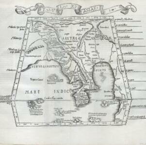
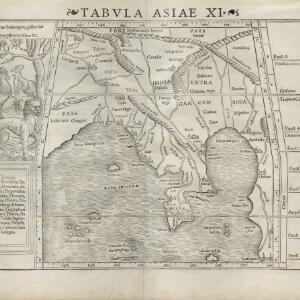
Vndecima Asiae Tabvla

event1511

location_onCambodia, Laos, Malaysia, Myanmar, Singapore, Thailand, Vietnam

Based on the work of 2nd century geographer Ptolemy, Bernardo Silvani’s woodcut map is innovative in its use of two colours: a black background with important text added in red. The Malay Peninsula is labelled ‘Aurea Chersonesus [Golden Chersonese]’.

Tabvla XI Asiae

event1522

location_onCambodia, Indonesia, Laos, Malaysia, Myanmar, Singapore, Thailand, Vietnam, Southeast Asia

Early map by Lorenz Fries, based on the work of 2nd century geographer Ptolemy. The Malay Peninsula—labelled ‘Aurea Chersone [Golden Chersonese]’—is recognisable. A drawing on the reverse features cannibals with dog’s heads chopping up human bodies.

India Orientalis

event1535

location_onMalaysia, Indonesia, Southeast Asia

This early map of Asia includes text describing the local people, their religious beliefs, crops, spices etc. On the island labelled Angama there is a drawing of anthropophagi—members of a mythical race of cannibals—chopping up a human body.

Tabv moder Indiae

event1535

location_onCambodia, Indonesia, Malaysia, Myanmar, Thailand, Vietnam

Early map of Asia, with the islands of Taprobana (Sumatra) to the west of the Malay Peninsula, and Timonia (Tioman) to the east. Text gives details of local economies: sandalwood on Tioman, and silver and silk at Lamai near Mallaqua (Malacca).

Tabula noua Indiæ orientalis & meridionalis

event1541

location_onMalaysia, Indonesia, Southeast Asia

This early map of Asia includes text describing the local people, their religious beliefs, crops, spices etc. On the island labelled Angama there is a drawing of anthropophagi—members of a mythical race of cannibals—chopping up a human body.

Tabvla Asiae XI

eventc.1542-1552

location_onCambodia, Indonesia, Malaysia, Myanmar, Singapore, Thailand, Vietnam, Southeast Asia

Early map by Sebastian Münster, based on the work of 2nd century geographer Ptolemy. The Malay Peninsula—labelled ‘Aurea Chersonesus [Golden Chersonese]’—is recognisable. An illustration shows the local animals: a tiger, cockerels and a white parrot.

Tabvla Asiae VIII

eventc.1545-1552

location_onMyanmar

Early map by Sebastian Münster, based on the work of 2nd century geographer Ptolemy, featuring strange deformed monsters, including headless men with faces on their torsos, a man with a dog’s head, and a mythical race of cannibals (‘Anthropophagi’).

Asie

event1575

location_onBrunei, Cambodia, East Timor, Indonesia, Laos, Malaysia, Myanmar, Philippines, Singapore, Southeast Asia, Thailand, Vietnam

A colourful 16th century map by André Thevet, with illustrations of ships and sea monsters around the seas of Southeast Asia. The map's scale is decorated with cartography tools such as rulers and a compass.

Indiae Orientalis insularumque adiacientium typus

event1579

location_onBrunei, Cambodia, East Timor, Indonesia, Laos, Malaysia, Myanmar, Philippines, Singapore, Southeast Asia, Thailand, Vietnam

A red banner at the right features text that notes that the ‘Insule Molucce’ (Maluku Islands) are famous for their abundance of spices, which are sold across the world. There are also Illustrations of mermaids and sea monsters wrecking a ship.

Asia secvnda pars terræ in forma Pegasi

event1581

location_onCambodia, Laos, Malaysia, Thailand, Vietnam, Myanmar

This map depicts Asia in the form of the mythical winged horse Pegasus, with mainland Southeast Asia being represented by the left hind leg. It is from the German theologian Heinrich Bünting's book of woodcut maps ‘Itinerarium Sacrae Scripturae’.

[Sumatra]

event1581

location_onIndonesia

This early map of Sumatra—referred to in the accompanying French text as ‘Isle de la Taprobane’—is covered with illustrations of people working on the land, and with elephants and camels. Villages, mountains, rivers and wild animals are also shown.

Sumatra ein grosse Insel: so von den alten Geographen Taprobana genennet worden

eventc.1588-1628

location_onIndonesia, Malaysia, Singapore, Thailand

A map of Sumatra featuring villages, mountains and rivers; text describing the island; and a drawing of a man riding an elephant. The title uses the name ‘Taprobana’ for Sumatra, stating it was a name used by ‘ancient geographers [alten geographen]’.

close