Search Results

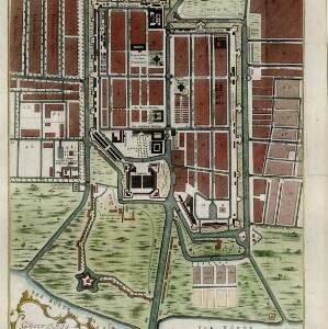
Grundris der stadt und citadelle Batavia
1785
Indonesia
A plan of the port of Batavia with a detailed legend identifying parts of the city. The sword and laurel wreath of the city’s coat of arms, and the Dutch East India Company flag (marked ‘VOC’ or ‘Vereenigde Oost Indische Compagnie’) are also shown.
- Filter from 1785 to 1871
- [remove]Cartouche2
- [remove]Legend2
- Coat of Arms1
- Elevation1
- Illustration1
- [remove]Written Note/Details2
- Compass Rose1
- Contour Lines/Elevation1
- Longitude and Latitude1
- Scale1


