
Search Results


Carte de la Côte de Pégou, et de celle de Martaban
1775
Myanmar
Navigation map of the coast of the ancient kingdom of Pégou and near the town of Martaban (Mottama), Myanmar. Bathymetry (sea depth), anchor points, notes on currents and obstructions are marked, and there are drawings of side views of coastal hills.
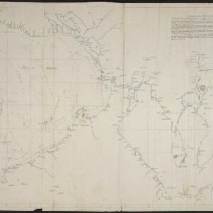

Plan de Salangor et de La Cote de Malaye: depuis la Pointe de Caran jusqu'au Mont Parcelar
1775
Malaysia
Map of the coast of Selangor on the west of the Malay Peninsula. The web of lines is a rhumbline network, the numbers indicate sea depth (bathymetry), and there are drawings of the side views of mountains (elevations), all to aid navigation.

A new chart of the straits of Sunda: From the manuscript of the Dutch East India Company
1794
Indonesia
Navigation chart of the Sunda Strait, showing bathymetry (sea depth), shoals and reefs, landmarks, and a rhumbline network. Notes record good anchorages, sources of water and supplies etc. Inset map of the Zutphen Islands off the coast of Sumatra.

An Spherical Chart of a part of the Archipelago of the Phillipine Islands
1804
Philippines
A hand-drawn map designed to aid navigation around the southern coast of Luzon and the islands of the central Philippines. It features side views of coastal hills and mountains (‘elevations’) to use as landmarks, as well as towns, shoals and reefs.

The continent and islands of Asia: with all the latest discoveries
1809
Vietnam, Myanmar, Papua New Guinea, Philippines, Singapore, Southeast Asia, Thailand, Malaysia, Laos, Indonesia, East Timor, Cambodia, Brunei
Southeast Asia is on the last sheet of this map of Asia. The South China Sea is labelled ‘Malayan Sea’. Small islands, shoals and reefs are shown. A label in Cochin China (Vietnam) reads ‘mountains inhabited by the uncivilized people called Kemoys’.
[Manuscript map of Manila Harbor and Bay Lake]
1810
Philippines
This early 19th century hand-drawn map of Manila Bay has detailed instructions in Spanish on how to enter the bay, and the port at Cavite. Bathymetry (water depth), the mouths of rivers, and landmark mountains are shown to aid navigation.

A map of Java: chiefly from surveys made during the British administration
1817
Indonesia
Made for ‘A History of Java’ by Sir Stamford Raffles, this map includes a list of administrative districts with their populations, and four inset maps of harbours. Another inset map shows rocks and minerals, mountains and volcanoes, and teak forests.
- Filter from 1602 to 1900
- [remove]Maritime Route56
- Bathymetry42
- Tide Data9
- Current Data5
- [remove]Mountain/Volcano56
- Wetlands20
- Jungle/Wooded Area13
- Mangrove5
- [remove]Written Note/Details56
- Longitude and Latitude48
- Contour Lines/Elevation38
- Scale37
- Compass Rose27
- Rhumbline Network5


