
Search Results
5 Results found


Tabvla Asiae XI
1574
Cambodia, Indonesia, Malaysia, Laos, Myanmar, Singapore, Thailand, Vietnam, Southeast Asia
Mid-16th century map by Girolamo Ruscelli, based on the work of 2nd century geographer Ptolemy. It is difficult to pinpoint exact locations, but the Malay Peninsula is recognisable. Italian text on the reverse describes the region.

Tabvla Asiae XI
1561
Cambodia, Indonesia, Malaysia, Laos, Myanmar, Singapore, Thailand, Vietnam, Southeast Asia
Mid-16th century map by Girolamo Ruscelli, based on the work of 2nd century geographer Ptolemy. It is difficult to pinpoint exact locations, but the Malay Peninsula is recognisable. Italian text on the reverse describes the region.
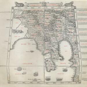
Vndecima Asiae Tabvla
1511
Cambodia, Laos, Malaysia, Myanmar, Singapore, Thailand, Vietnam
Based on the work of 2nd century geographer Ptolemy, Bernardo Silvani’s woodcut map is innovative in its use of two colours: a black background with important text added in red. The Malay Peninsula is labelled ‘Aurea Chersonesus [Golden Chersonese]’.


