Search

Search Results

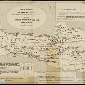
Spoor- en tramwegkaart van Java en Madoera

event1894

location_onIndonesia

The railways and tramways of Java and Madoera (Madura) are shown on this late 19th century map, including lines in use, under construction, and being planned. Each line is named, with their route, length, track gauge and construction costs listed.

Java

event1894

location_onIndonesia

This detailed late 19th century map shows Java divided into regencies, and features mountains, land and sea routes, and an inset map of the port city of Batavia (Jakarta). It was designed to be folded within book covers so it could be easily carried.

Residentie Preanger Regentschappen

event1894

location_onIndonesia

Large-scale topographic map of the residency of Preanger (West Java) spread over multiple sheets plus a cover sheet of the whole area. It is divided into regencies, departments and districts. Only nine sheets and the cover sheet are available.

Topographische Kaart der residentie Cheribon

event1894

location_onIndonesia

Six-sheet topographic map of the residency of Cheribon (Cirebon, West Java), with an inset of a geodesic triangle grid. Administrative districts, crops—rice, alang-alang, sugarcane, sugar, coffee, tea—and indigo plant mills are shown.

Kaart van der residentie Soerabaja

event1893

location_onIndonesia

A map of the residency of Soerabaja (East Java) divided into regencies, departments and districts. There are large fishing ponds around the coasts. An inset map shows distances between settlements by road, tracks and paths.

Keij of Ewaf eilanden

event1893

location_onIndonesia

Map of the Kai Islands, in the Banda Sea, designed for navigation: it features bathymetry (sea depth), reefs and shoals. Obstructions in the water are marked ‘kr’ (coral), ‘m’ (mud), ‘s’ (shells), ‘st’ (stones), and ‘z’ (sand).

Kaart van de residentie Preanger regentschappen

event1893

location_onIndonesia

A map of the residency of Preanger (West Java) spread over three sheets and divided into regencies, departments and districts. An inset map shows distances between cities, towns and villages by road, tracks and paths.

Plannen van ankerplaatsen Kleine Soenda eilanden

event1893

location_onIndonesia

Fifty-seven separate maps of bays, roadsteads—a body of water sheltered from tides/currents—and anchor points around the Lesser Sunda Islands. Landmarks, lighthouses, bathymetry (sea depth), shoals, reefs and other obstructions are marked.

Kaart van de dichtheid van bevolking van Java en Madoera

event1892

location_onIndonesia

This map shows the population density of Java and Madura in 1892. The area is divided into regencies, which are then subdivided into districts, with the districts shaded to represent its population. Each district is also listed under its regency.

Kaart van den op Java en Madoera reeds in gebruik genomen grond

event1892

location_onIndonesia

Land usage statistics are shown on this map of Java and Madura. The amount of land used in each district is indicated by green hash marks, and by a number giving its land use percentage. District names are listed and identified by a letter.

Kaart van de Residentie Kediri

event1891

location_onIndonesia

A map of the residency of Kediri (East Java) divided into regencies, which are then subdivided into districts. Mountains, roads, railways and rivers are shown. An inset map shows distances between settlements by road, tracks and paths.

Kaart van het gebied bezet in Groot-Atjeh

event1891

location_onIndonesia

A map of Groot-Atjceh and the city of Kota Radja (modern Banda Aceh) at the northern tip of Sumatra, detailing routes (rivers, roads, railways), crops (rice, banana, sugarcane, betel, reed, alang-alang, bamboo) and land features (forests, wetlands).

close