
Search Results


Mer des Indes: cartes de la direction et de l'intensité probables des vents
1880
Brunei, Cambodia, Indonesia, Malaysia, Myanmar, Philippines, Thailand, Vietnam, Singapore
A series of four maps of the Indian Ocean—one for each quarter of the calendar year—showing the direction and intensity of the winds, including around the seas of Southeast Asia. There are extensive explanatory notes.
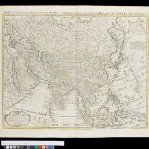
Carte d'Asie: dressée sur les memoires envoyéz par le Czar a l'Academie Royale des Science
c.1722-1774
Brunei, Cambodia, East Timor, Indonesia, Laos, Malaysia, Myanmar, Philippines, Singapore, Southeast Asia, Thailand, Vietnam
An early 18th century map of Asia by the French cartographer Guillaume Delisle (1675–1726). Regions are indicated with coloured borders, and the southern part of Borneo is labelled ‘Côte de Mahometans [Coast of the Muslims]’.
- Longitude and Latitude3
- [remove]Written Note/Details3
- Contour Lines/Elevation1
- Scale1


