
Search Results

Isole dell'Indie divise in Filippine, Molucche e della Sonda
1680
Brunei, Cambodia, East Timor, Indonesia, Malaysia, Laos, Myanmar, Philippines, Singapore, Southeast Asia, Thailand, Vietnam
Dotted lines and colours divide maritime Southeast Asia into three regions on this map: the Philippine archipelago, Maluku Islands and Sunda Islands. The cartouche features cherub mermaids, and a map of mainland Southeast Asia is on the reverse.

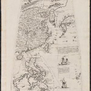
Isole Molvcche
1605
Brunei, Cambodia, Indonesia, Laos, Malaysia, Philippines, Singapore, Southeast Asia, Thailand, Vietnam, East Timor
This map shows some inaccuracies, especially in the shape of the Malay Peninsula and the islands meant to represent Sumatra (labelled ‘Camatra’), Java (‘Iava Mazor’) and Borneo (‘Iava Menor’). Latin text describes the Maluku Islands.

India tercera nvova tavola
1561
Cambodia, Indonesia, Laos, Malaysia, Myanmar, Philippines, Singapore, Southeast Asia, Thailand, Vietnam, Brunei
This mid-16th century map of Southeast Asia shows some inaccuracies, especially in the shape of the Malay Peninsula and the islands meant to represent Sumatra (labelled ‘Camatra’), Java (‘Iava Mazor’) and Borneo (‘Iava Menor’). Latin text on reverse.
- Filter from 1561 to 1693
- [remove]Italian4
- [remove]Written Note/Details4
- Longitude and Latitude3
- Compass Rose1
- Scale1


