
Search Results
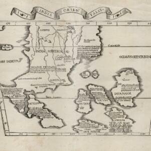
Tabula noua Indiæ orientalis & meridionalis
1541
Malaysia, Indonesia, Southeast Asia
This early map of Asia includes text describing the local people, their religious beliefs, crops, spices etc. On the island labelled Angama there is a drawing of anthropophagi—members of a mythical race of cannibals—chopping up a human body.

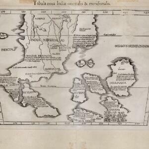
India tercera nvova tavola
1561
Cambodia, Indonesia, Laos, Malaysia, Myanmar, Philippines, Singapore, Southeast Asia, Thailand, Vietnam, Brunei
This mid-16th century map of Southeast Asia shows some inaccuracies, especially in the shape of the Malay Peninsula and the islands meant to represent Sumatra (labelled ‘Camatra’), Java (‘Iava Mazor’) and Borneo (‘Iava Menor’). Latin text on reverse.
Asie
1575
Brunei, Cambodia, East Timor, Indonesia, Laos, Malaysia, Myanmar, Philippines, Singapore, Southeast Asia, Thailand, Vietnam
A colourful 16th century map by André Thevet, with illustrations of ships and sea monsters around the seas of Southeast Asia. The map's scale is decorated with cartography tools such as rulers and a compass.

Indiae Orientalis insularumque adiacientium typus
1579
Brunei, Cambodia, East Timor, Indonesia, Laos, Malaysia, Myanmar, Philippines, Singapore, Southeast Asia, Thailand, Vietnam
A red banner at the right features text that notes that the ‘Insule Molucce’ (Maluku Islands) are famous for their abundance of spices, which are sold across the world. There are also Illustrations of mermaids and sea monsters wrecking a ship.
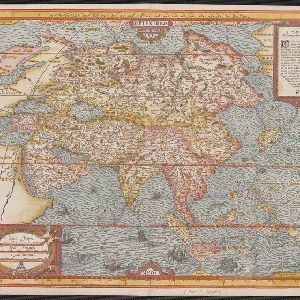
Asia wie es jetziger zeit nach den fuernemesten Herrschafften abgetheilet und beschriben ist
c.1588-1628
Brunei, Cambodia, East Timor, Indonesia, Laos, Malaysia, Myanmar, Philippines, Singapore, Southeast Asia, Thailand, Vietnam
This early German map of Asia is colour-coded by region, and features a brief description of Asia in blackletter German text. Interestingly, the Southeast Asian island of Sumatra is labelled 'Taprobana' which is the name the Greeks called Sri Lanka.

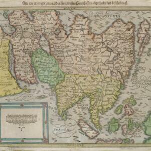
Exacta & accurata delineatio cùm orarum maritimarum tùm etiam locorum terrestrium quae in regionibus China, Cauchinchina, Camboia sive Champa, Syao, Malacca, Aracan & Pegu
1595
Brunei, Cambodia, East Timor, Indonesia, Laos, Malaysia, Myanmar, Philippines, Singapore, Southeast Asia, Thailand, Vietnam
Unusually, north is located to the left of this map of East Asia, rather than the top. The text notes that shallows and reefs are marked, and that the map is based on the explorations of Portuguese ships. Illustrations include sea monsters and ships.

Exacta & accurata delineatio cùm orarum maritimarum tùm etiam locorum terrestrium quae in regionibus China, Cauchinchina, Camboia sive Champa, Syao, Malacca, Aracan & Pegu
1596
Brunei, Cambodia, East Timor, Indonesia, Laos, Malaysia, Myanmar, Philippines, Singapore, Southeast Asia, Thailand, Vietnam
Unusually, north is located to the left of this map of East Asia, rather than the top. The text notes that shallows and reefs are marked, and that the map is based on the explorations of Portuguese ships. Illustrations include sea monsters and ships.
- Filter from 1535 to 1900
- Indonesia165
- Malaysia152
- Brunei143
- Singapore142
- Philippines138
- Vietnam132
- Cambodia131
- East Timor131
- Thailand131
- Southeast Asia128
- Laos127
- Myanmar126
- more Simple Location »
- [remove]Borneo165
- Sumatra148
- Java137
- Sulawesi111
- Malay Peninsula100
- Celebes93
- Maluku Islands84
- Western New Guinea80
- Siam59
- Sunda Islands51
- Malacca48
- Pegu45
- more Detailed Location »
- [remove]Written Note/Details165
- Longitude and Latitude156
- Scale103
- Compass Rose57
- Contour Lines/Elevation30
- Rhumbline Network18


