
Search Results


Kaart van de residentie Wester-afdeeling van Borneo
1898
Indonesia
Topographical map of western Borneo. Larger settlements are marked with their height above sea-level and with a flag to indicate a military garrison. They also have a letter signifying the local ruler, from Sultan to Lauthai (village elder).


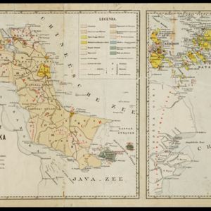
Atlas van Nederlandsch Oost-Indië
c.1897-1904
Indonesia
Very detailed atlas of the entire Dutch East Indies, over 16 map sheets, with a cover and overview map. Includes topographic maps, inset maps of cities and islands, and maps featuring land and sea routes, languages, geology, colonial territory etc.

Plannen van ankerplaatsen Kleine Soenda eilanden
1893
Indonesia
Fifty-seven separate maps of bays, roadsteads—a body of water sheltered from tides/currents—and anchor points around the Lesser Sunda Islands. Landmarks, lighthouses, bathymetry (sea depth), shoals, reefs and other obstructions are marked.

Kaart der Bataklanden en van het eiland Nijas
1890
Indonesia
A large-scale map of northern Sumatra, spread over 16 sheets, and divided into administrative regions. The island of Nijas (Nias) is marked with the locations of local tribes, and there is a list of other maps referenced in producing the map.
Schets-taalkaart van de residentie Bangka / Schets-taalkaart van den Riouw- en Lingga-archipel
1889
Indonesia
Two separate maps showing the languages and dialects spoken on the islands of Bangka, and the Riouw (Riau) and Lingga archipelagos, in the late 19th century. On Bangka alone, there are 12 languages or dialects listed.

Westkust Borneo: Mond der Padang-Tikar rivier
1884
Indonesia
Navigation map of the mouth of the Padang Tikar River, on the west coast of Borneo, featuring bathymetric (water depth) routes. Obstructions are marked with letters: ‘m’ (mud), ‘z’ (sand). Trees, hills and fishermen’s houses are shown as landmarks.
- Filter from 1853 to 1899
- Dutch19
- Longitude and Latitude19
- [remove]Written Note/Details19
- Contour Lines/Elevation18
- Scale18
- Compass Rose3


