Search Results
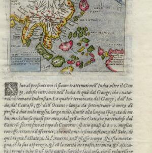
Indiae Orientalis insularumque adiacientium typus
c.1596-1640
Brunei, Cambodia, East Timor, Indonesia, Laos, Malaysia, Myanmar, Philippines, Singapore, Southeast Asia, Thailand, Vietnam
Rivers and major settlements are the main feature of this colourful early map of Asia. Italian text gives further details about the region.
- Indonesia54
- Malaysia19
- Singapore16
- East Timor14
- Myanmar13
- Philippines13
- Thailand13
- Brunei12
- Cambodia12
- Laos10
- Vietnam10
- Southeast Asia9
- more Simple Location »
- Java38
- Sumatra27
- Batavia23
- Jakarta22
- Borneo20
- Dutch East Indies18
- Malay Peninsula14
- Maluku Islands14
- Sulawesi13
- Celebes12
- Java Sea11
- Western New Guinea10
- more Detailed Location »
- Military Fort32
- Kampong/Village20
- Residential Area17
- Church16
- Cemetery/Columbarium14
- Hospital14
- Military Barracks8
- Post Office7
- Public Space7
- Court of Law6
- Palace6
- Communal Land/Property4
- Jail/Prison4
- Police Station4
- more Settlement Features »
- [remove]Port62
- Pier19
- Railway Station3
- [remove]Written Note/Details62
- Scale45
- Longitude and Latitude43
- Compass Rose33
- Contour Lines/Elevation18
- Rhumbline Network8
- Keyser, Jacob3
- Moll, Herman3
- Pontanus, Johannes Isacius3
- Reland, Adriaan3
- Versteeg, W.F.3
- Wright, Benjamin3
- Après de Mannevillette, Jean-Baptiste d'2
- Berghaus, Heinrich Karl Wilhelm2
- more Map Maker »
- Gerard van Keulen4
- Topographische Inrichting4
- Chez Demonville2
- François L'Honoré & Compagnie2
- Hendrik Hondius2
- Herman Moll2
- Homann Heirs2
- John King2
- more Printer/Publisher »
- Amsterdam21
- London10
- The Hague8
- Batavia4
- Paris3
- Frankfurt2
- Gotha2
- Edinburgh1
- more Place of Publication »