
Search Results
Filter
Commerce
Factory
Remove constraint Commerce: Factory
Cultivation/Extraction
Plantation/Forestry Area
Remove constraint Cultivation/Extraction: Plantation/Forestry Area
Insets
Legend
Remove constraint Insets: Legend
Land Routes
Canal
Remove constraint Land Routes: Canal
Transport Hubs
Pier
Remove constraint Transport Hubs: Pier
Collections
Leiden University Libraries
Remove constraint Collections: Leiden University Libraries
3 Results found


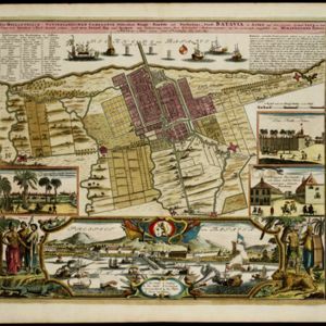
Der Hollaendisch-Ostindianischen Compagnie weltberühmte Haupt-Handels und Niederlags: Stadt Batavia
1733
Indonesia
The legend and written notes on this plan of Batavia (Jakarta) provide much detailed information about the important port city in the early 18th century. It is also beautifully decorated with paintings of the city, local people, animals and ships.
- [remove]Factory3
- Market2
- Office1
- Shopping Area1
- Warehouse1
- Crops3
- [remove]Plantation/Forestry Area3
- Fishing2
- Domesticated Animals1


