
Search Results


Kaart van de Afdeeling Ngrowo (Residentie Kediri)
1855
Indonesia
Map of the administrative department of Ngrowo, Java. A list gives heights above sea level of some mountains and villages, and a note locates a sugar factory. (From ‘Algemeene Atlas van Nederlandsche Indie [General Atlas of the Dutch East Indies]’.)


Algemeene Atlas van Nederlandsche Indie
c.1853-1862
Indonesia
Atlas featuring over 60 detailed maps of the Dutch East Indies: 24 maps cover Java; the remainder cover the rest of the Dutch East Indies. There are three index maps. (All the maps in this atlas are also presented separately on this platform.)

Map of the Burman Empire including also Siam, Cochin-China, Ton-king and Malaya
1842
Vietnam, Malaysia, Myanmar, Cambodia, Thailand, Laos, Indonesia, Singapore, Brunei
Although this mid-19th century map covers all of mainland Southeast Asia, the Burman Empire (Myanmar) is shown in greater detail, especially its districts, rivers and place names. It was produced by the James Wyld, geographer to Queen Victoria.

Map of the Burman Empire including also Siam, Cochin-China, Ton-king and Malaya
1842
Vietnam, Myanmar, Malaysia, Indonesia, Thailand, Laos, Cambodia, Brunei, Singapore
Regional borders are colour-coded on this mid-19th century map of mainland Southeast Asia, with British colonial territory in red (including part of the Burman Empire, the Straits Settlements, and Sarawak on Borneo).

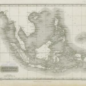
Eastern islands or Malay archipelago
1836
Brunei, Cambodia, East Timor, Indonesia, Laos, Malaysia, Myanmar, Philippines, Singapore, Southeast Asia, Vietnam, Thailand
Brief notes printed on this 19th century map of Southeast Asia provide details about each region, including: numbers and ethnicity of the population, local or colonial rulers, crops and products, geography (corals, forests, volcanos, earthquakes).

Map of the Burman Empire including also Siam, Cochin-China, Ton-king and Malaya
1832
Vietnam, Myanmar, Malaysia, Indonesia, Thailand, Laos, Cambodia, Brunei, Singapore
Regional borders are colour-coded on this mid-19th century map of mainland Southeast Asia, with British colonial territory in red (including part of the Burman Empire, the Straits Settlements, and Sarawak on Borneo).
East India Islands
1817
Brunei, Cambodia, East Timor, Indonesia, Laos, Malaysia, Myanmar, Philippines, Singapore, Southeast Asia, Thailand, Vietnam
Although there is not much detail on this early 19th century map of Southeast Asia, in addition to place names, some rivers and ports are named, and there is even a ‘Dutch Factory’ on the west coast of Malaya.
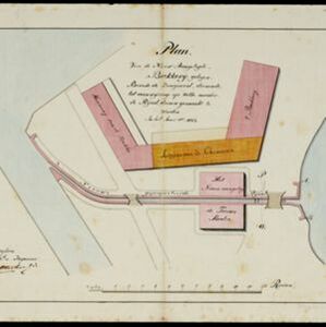
Plan van de nieuw aangelegde bakkerij, gelegen beweste de zaagmool
1812
Indonesia
A plan of a bakery in an unknown location in the Dutch East Indies, next to a proposed water channel (‘rijool’) intended to power a saw mill. There are two additional sheets showing construction drawings of the water channel, with piling underneath.


[Sumatra and the Strait of Malacca]
c.1800
Malaysia, Singapore, Indonesia
Chart of maritime Southeast Asia, showing bathymetry (sea depth), islands, shoals, reefs, landmarks, and notes (‘Rock seen at Low Water’), all to aid navigation. A rhumbline network has been drawn on the map in pencil. Only one sheet is present.


