
Search Results


Nederlandsch Oost-Indië
1865
Brunei, Cambodia, East Timor, Indonesia, Laos, Malaysia, Myanmar, Vietnam, Thailand, Southeast Asia, Singapore, Philippines, Papua New Guinea
This detailed map of the Dutch East Indies in the mid-19th century contains a great deal of information: topographical details, settlements and administrative areas, roads, railways and maritime routes, telegraph lines, inset maps etc.


Kaart van de Oosterhelft der Residentie Samarang
1858
Indonesia
Map of the Dutch colonial administrative region (residency) of Samarang (Semarang, Java) with ruined temples, a sugar factory, tobacco warehouse and rice mill. (From ‘Algemeene Atlas van Nederlandsche Indie [General Atlas of the Dutch East Indies]’.)

Kaart van de westerhelft der residentie Rembang
1858
Indonesia
Topographic map of the residency of Rembang, Central Java, divided into regencies and districts. Roads and villages are marked, with shoals, reefs and water depth at sea. An inset map of the city of Rembang features markets, warehouses, churches.

Kaart van de Residentie Preanger Regentschappen: No. I
1857
Indonesia
Map of the Dutch colonial administrative region (residency) of Preanger Regentschappen, Java with warehouses, factories, mills, cinchona (‘kina’) plantations. (From ‘Algemeene Atlas van Nederlandsche Indie [General Atlas of the Dutch East Indies]’.)

Kaart van de Residentie Preanger Regentschappen: No. II
1857
Indonesia
Map of the Dutch colonial administrative region (residency) of Preanger Regentschappen, Java with warehouses, factories, mills, cinchona (‘kina’) plantations. (From ‘Algemeene Atlas van Nederlandsche Indie [General Atlas of the Dutch East Indies]’.)
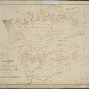
Kaart der afdeeling Poerbolingo: Residentie Banjoemaas
1857
Indonesia
The legend on this hand-drawn map of the district of Poerbolingo (Purbalingga), Central Java, includes ‘hoofd plaats [main town]’, ‘dessa [village]’, ‘doekoeh [farm]’, ‘indigofabriek [indigo plant mill]’ and ‘koffypakhuis [coffee warehouse]’.

Kaart van de voornaamsten der Banda Eilanden
1854
Indonesia
Map of the Banda Islands, with a volcano on Goenong Api, two forts (‘Ft. Belgica’ and ‘Ft. Nassau’) on Neira, and a list of the heights of the mountains. (From ‘Algemeene Atlas van Nederlandsche Indie [General Atlas of the Dutch East Indies]’.)


Map of the River of Don-nai from Cape St. James to the city of Saigon
1820
Vietnam
A map to aid in the navigation of the rivers leading to Saigon (Ho Chi Minh City, Vietnam). Details include bathymetry (water depth), currents, and a side view (or ‘elevation’) of hills to use as a landmark. Tides are described in written remarks.

De Groote Siamse Rievier Me-Nam, ofte Moeder der Wateren: In haren loop met de in vallende Spruyten Verbeeld
1726
Thailand
Map of the Me-nam River (Chao Phraya River) with the city of Ayutthaya (labelled ‘Siri India’) in the centre. Its mouth at the Gulf of Thailand is to the left. Over 100 buildings, towns and other places are shown pictorially and listed in the legend.


