
Search Results


Carte d'une partie de la Cote de Cochinchine: depuis l'Isle Cham-Collao jusqu'à la Riv. du Roi
1775
Vietnam
A map to aid navigation around the Bay of Touranne (Bay of Turon, location of modern city of Da Nang, Vietnam). The web of lines is a rhumbline network, and bathymetry (sea depth), anchor points and two elevation views of the coasts are shown.


Plan de Salangor et de La Cote de Malaye: depuis la Pointe de Caran jusqu'au Mont Parcelar
1775
Malaysia
Map of the coast of Selangor on the west of the Malay Peninsula. The web of lines is a rhumbline network, the numbers indicate sea depth (bathymetry), and there are drawings of the side views of mountains (elevations), all to aid navigation.

Carte de la Côte de Pégou, et de celle de Martaban
1775
Myanmar
Navigation map of the coast of the ancient kingdom of Pégou and near the town of Martaban (Mottama), Myanmar. Bathymetry (sea depth), anchor points, notes on currents and obstructions are marked, and there are drawings of side views of coastal hills.

Plan de Salangor et de La Cote de Malaye: depuis la Pointe de Caran jusqu'au Mont Parcelar
1775
Malaysia
Map of the coast of Selangor on the west of the Malay Peninsula. The web of lines is a rhumbline network, the numbers indicate sea depth (bathymetry), and there are drawings of the side views of mountains (elevations), all to aid navigation.
Carte de la Côte de Pégou, et de celle de Martaban
1775
Myanmar
Navigation map of the coast of the ancient kingdom of Pégou and near the town of Martaban (Mottama), Myanmar. Bathymetry (sea depth), anchor points, notes on currents and obstructions are marked, and there are drawings of side views of coastal hills.

Carte des Indes Orientalis
1748
Brunei, Cambodia, East Timor, Indonesia, Laos, Malaysia, Myanmar, Philippines, Singapore, Southeast Asia, Vietnam, Thailand
This mid-18th century map features labels noting the local populations, including the Kemois of the mountains and deserts of Cochinchinae (Vietnam) and the Byayos of Borneo. The map’s cartouche is embellished with maritime and military paraphernalia.

Carte des Indes Orientales: I. feuille
1748
Myanmar, Cambodia, Indonesia, Laos, Malaysia, Singapore, Thailand, Vietnam
Map featuring the ancient kingdoms of mainland Southeast Asia. The cartouche is embellished with maritime and military paraphernalia. The map is dedicated to William IV, Prince of Orange (Guillaume Charles Henry Friso). Sheet one of two.
Carte des Indes Orientales: 2de. feuille
1748
Brunei, East Timor, Indonesia, Malaysia, Philippines, Vietnam
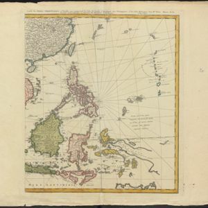
This map features a label noting that the Byayos people inhabited the mountains of central Borneo. Another note at the northeast tip of Borneo states that the location and number of islands in the area is uncertain. Sheet two of two.
Carte des Indes Orientales: I. feuille
1748
Myanmar, Cambodia, Indonesia, Laos, Malaysia, Singapore, Thailand, Vietnam
Map featuring the ancient kingdoms of mainland Southeast Asia. The cartouche is embellished with maritime and military paraphernalia. The map is dedicated to William IV, Prince of Orange (Guillaume Charles Henry Friso). Sheet one of two.
Carte des Indes Orientales: 2de. feuille
1748
Brunei, East Timor, Indonesia, Malaysia, Philippines, Vietnam
This map features a label noting that the Byayos people inhabited the mountains of central Borneo. Another note at the northeast tip of Borneo states that the location and number of islands in the area is uncertain. Sheet two of two.
- Filter from 1748 to 1794
- [remove]Mountain/Volcano12
- Jungle/Wooded Area2
- Wetlands2
- [remove]Après de Mannevillette, Jean-Baptiste d'12
- Mayer, Tobias5
- Delahaye, Guillaume-Nicolas2
- Le Floch de la Carrière2


