Search

Search Results

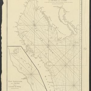
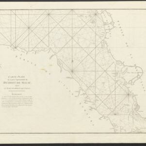
Naauwkeurige kaart van het oostlijk gedeelte van Straat Malacca

eventc.1780

location_onMalaysia, Indonesia, Singapore

This map of the Straits of Malacca features shoals and reefs, bathymetry (sea depth), drawings of side views of landmark mountains (elevations), all designed to aid navigation. The various straits used around Singapore are also marked.

Carte Plate du Golfe de Siam: avec une partie des Côtes de Malaye et de Camboje, depuis l'Isle Timon, jusqu'à celle Condor

event1775

location_onCambodia, Malaysia, Thailand

Map of the Gulf of Siam (Gulf of Thailand) with shoals and small islands marked. The web of lines is a rhumbline network, while the numbers indicate sea depth (bathymetry), both used to aid navigation. There is an inset map of the Redang Archipelago.

Plan de Salangor et de La Cote de Malaye: depuis la Pointe de Caran jusqu'au Mont Parcelar

event1775

location_onMalaysia

Map of the coast of Selangor on the west of the Malay Peninsula. The web of lines is a rhumbline network, the numbers indicate sea depth (bathymetry), and there are drawings of the side views of mountains (elevations), all to aid navigation.

Carte Plate de la Partie Septentrionale du Détroit de Malac: depuis la Rade D'Áchem jusqu'a Malac

event1775

location_onIndonesia, Malaysia

Map of the northern Malacca Strait—between Sumatra and Malaya—with shoals and reefs marked, some labelled as ‘dangerous’. The web of lines is a rhumbline network, while the numbers indicate sea depth (bathymetry), both used to aid navigation.

Carte des Indes Orientales: I. feuille

event1748

location_onMyanmar, Cambodia, Indonesia, Laos, Malaysia, Singapore, Thailand, Vietnam

Map featuring the ancient kingdoms of mainland Southeast Asia. The cartouche is embellished with maritime and military paraphernalia. The map is dedicated to William IV, Prince of Orange (Guillaume Charles Henry Friso). Sheet one of two.

Chart of the China Sea

event1746

location_onBrunei, Cambodia, Indonesia, Malaysia, Philippines, Vietnam

This map features eight expedition routes across the South China Sea from 1752 to 1763. The web of lines is a rhumbline network, and bathymetry (sea depth) is marked. The place names are in French, but with an English title and notes.

close

  • Filter from 1746 to 1780

Current results range from 1746 to 1780