
Search Results


Algemeene Kaart van het Nederlandsch Gebied op het Eiland Borneo: No. I
1859
-
Map of the Dutch colonial administrative regions of western Borneo, featuring mountains, rivers and settlements. (One of four sheets covering Borneo from ‘Algemeene Atlas van Nederlandsche Indie [General Atlas of the Dutch East Indies]’.)

Algemeene Kaart van het Nederlandsch Gebied op het Eiland Borneo: No. II
1859
Indonesia
Map of the Dutch colonial administrative regions of southwest Borneo, featuring mountains, rivers and settlements. (One of four sheets covering Borneo from ‘Algemeene Atlas van Nederlandsche Indie [General Atlas of the Dutch East Indies]’.)


Kaart van de Adsistent Residentie Benkoelen en van de Eilanden Bewesten Sumatra
1860
Indonesia
Map of part of the Dutch colonial administrative region (assistant residency) of Benkoelen (Bengkulu, Sumatra), with an inset map of the Mentawai Islands. (From ‘Algemeene Atlas van Nederlandsche Indie [General Atlas of the Dutch East Indies]’.)

Kaart van de Adsistent Residentie Benkoelen: Middendeel
1860
Indonesia
Map of part of the Dutch colonial administrative region (assistant residency) of Benkoelen (Bengkulu, Sumatra). Inset map of Nias Island and the Batu Islands. (From ‘Algemeene Atlas van Nederlandsche Indie [General Atlas of the Dutch East Indies]’.)

Kaart van de Adsistent Residentie Benkoelen: Noorderdeel
1860
Indonesia
Map of part of the Dutch colonial administrative region (assistant residency) of Benkoelen (Bengkulu, Sumatra). There is an inset map of the Banyak Islands. (From ‘Algemeene Atlas van Nederlandsche Indie [General Atlas of the Dutch East Indies]’.)

Kaart van de Oosterhelft der Residentie Palembang
1860
Indonesia
Map of the eastern half of the Dutch colonial administrative region (residency) of Palembang, Sumatra. A fort is marked in the town of Batoeradja. (From ‘Algemeene Atlas van Nederlandsche Indie [General Atlas of the Dutch East Indies]’.)

Kaart van de Oosterhelft der Residentie Timor
1860
Indonesia
Map of the eastern half of the Dutch colonial administrative region (residency) of Timor, with an inset map of its capital city and port Timorkoepang (Kupang). (From ‘Algemeene Atlas van Nederlandsche Indie [General Atlas of the Dutch East Indies]’.)
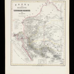
Kaart van de Residentie Lampongsche Districten
1860
Indonesia
Map of the Dutch colonial administrative region (residency) of Lampung at the southern tip of Sumatra, divided into five regencies (yellow borders). (From ‘Algemeene Atlas van Nederlandsche Indie [General Atlas of the Dutch East Indies]’.)
- Filter from 1858 to 1860
- Dutch14
- [remove]Kampong/Village14
- Military Fort4
- Post Office4
- Church2
- Mosque2
- Residential Area2
- Temple2
- Cemetery/Columbarium1
- Jail/Prison1
- Palace1


