
Search Results
Filter
Map Maker
Bellin, Jacques Nicolas
Remove constraint Map Maker: Bellin, Jacques Nicolas
Map Maker
Prévost, Abbé
Remove constraint Map Maker: Prévost, Abbé
Detailed Location
Sulawesi
Remove constraint Detailed Location: Sulawesi
Place of Publication
Paris
Remove constraint Place of Publication: Paris
3 Results found


Suite de l'Ocean Oriental contenant les Isles de la Sonde, les costes de Tunquin et de la Chine, les isles du Japon, les Philippines, Moluques
1746
Brunei, Cambodia, East Timor, Indonesia, Malaysia, Papua New Guinea, Philippines, Singapore, Thailand, Vietnam, Southeast Asia
The coast of New Guinea (‘Nouvelle Guinée’) is represented in part by a dotted line on this mid-18th century map, indicating that the exact coastlines were unknown at this time. The western tip is labelled ‘C. de Bonne Esperance [Cape of Good Hope]’.
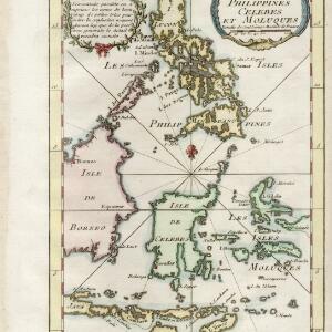
Carte des isles Philippines, Celebes et Moluques
c.1746-1770
Brunei, Malaysia, Philippines, Indonesia, East Timor
The note in French at the top left of this map states that although the map is accurate, the names of many small islands have been omitted to avoid confusion, and that more details will come later.


