
Search Results
Filter
Map Maker
Bry, Theodor de
Remove constraint Map Maker: Bry, Theodor de
Insets
Illustration
Remove constraint Insets: Illustration
Detailed Location
Borneo
Remove constraint Detailed Location: Borneo
Collections
National Library Board Singapore
Remove constraint Collections: National Library Board Singapore
4 Results found


Tabula geograph in qua Europae, Africae, Asiaeq et circujacentium insularum orae maritimae accurate describuntur et ad jntelligentia navigationum Indicaru accommodantur
1614
Brunei, Cambodia, East Timor, Indonesia, Laos, Malaysia, Myanmar, Vietnam, Thailand, Southeast Asia, Singapore, Philippines
A map decorated with drawings of indigenous people, including from Southeast Asia: a Moluccan soldier with a helmet, sword and shield; a Javanese warrior with a spear and shield; a Sumatran woman holding a flower; and a Malaccan man with a sword.

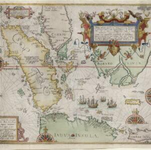
Nova tabula insularum Iavae, Sumatrae, Borneonis et aliarum Mallaccam usquae
1598
Malaysia, Indonesia, Singapore
Adapted by Theodore de Bry from an original by Willem Lodewycksz, this map has some inaccuracies e.g. the Malay Peninsula (‘Chersonese’) is completely bisected by the Muar River, leaving the southern tip of the peninsula as a separate island.


