Search Results
24 Results found
![](https://historicalmaps.yale-nus.edu.sg/rails/active_storage/representations/eyJfcmFpbHMiOnsibWVzc2FnZSI6IkJBaHBBcFlDIiwiZXhwIjpudWxsLCJwdXIiOiJibG9iX2lkIn19--d6193415a706e5df25956dc3533152bac3104c93/eyJfcmFpbHMiOnsibWVzc2FnZSI6IkJBaDdCam9MY21WemFYcGxTU0lNTkRBd2VETXdNQVk2QmtWVSIsImV4cCI6bnVsbCwicHVyIjoidmFyaWF0aW9uIn19--bc467f5637e8b6d3bfb826116f92b6bfedfbf03a/bodleian-0494.jpeg)
Kaart van de Gouvernement Sumatra's Westkust No. 1
1857
Indonesia
Map of part of the Dutch colonial administrative region of Sumatra’s Westkust (Sumatra’s West Coast). A route into the port of Sibogha (Sibolga) is marked. (From ‘Algemeene Atlas van Nederlandsche Indie [General Atlas of the Dutch East Indies]’.)
![](https://historicalmaps.yale-nus.edu.sg/rails/active_storage/representations/eyJfcmFpbHMiOnsibWVzc2FnZSI6IkJBaHBBcGNDIiwiZXhwIjpudWxsLCJwdXIiOiJibG9iX2lkIn19--545aa2113742580b358a8a6b51667ac5065e0bbe/eyJfcmFpbHMiOnsibWVzc2FnZSI6IkJBaDdCam9MY21WemFYcGxTU0lNTkRBd2VETXdNQVk2QmtWVSIsImV4cCI6bnVsbCwicHVyIjoidmFyaWF0aW9uIn19--bc467f5637e8b6d3bfb826116f92b6bfedfbf03a/bodleian-0495.jpeg)
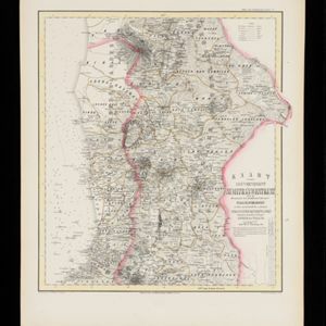
Kaart van de Gouvernement Sumatra's Westkust No. 2
1857
Indonesia
Map of part of the Dutch colonial administrative region of Sumatra’s Westkust (Sumatra’s West Coast). The sea is marked with bathymetry (sea depth). (From ‘Algemeene Atlas van Nederlandsche Indie [General Atlas of the Dutch East Indies]’.)
![](https://historicalmaps.yale-nus.edu.sg/rails/active_storage/representations/eyJfcmFpbHMiOnsibWVzc2FnZSI6IkJBaHBBcGdDIiwiZXhwIjpudWxsLCJwdXIiOiJibG9iX2lkIn19--f7d7050ad1b9d3edbfaa0c836e0c98644565afba/eyJfcmFpbHMiOnsibWVzc2FnZSI6IkJBaDdCam9MY21WemFYcGxTU0lNTkRBd2VETXdNQVk2QmtWVSIsImV4cCI6bnVsbCwicHVyIjoidmFyaWF0aW9uIn19--bc467f5637e8b6d3bfb826116f92b6bfedfbf03a/bodleian-0496.jpeg)
Kaart van de Gouvernement Sumatra's Westkust No. 3
1857
Indonesia
Map of part of the Dutch colonial administrative region of Sumatra’s Westkust (Sumatra’s West Coast). The sea is marked with bathymetry (sea depth). (From ‘Algemeene Atlas van Nederlandsche Indie [General Atlas of the Dutch East Indies]’.)
![](https://historicalmaps.yale-nus.edu.sg/rails/active_storage/representations/eyJfcmFpbHMiOnsibWVzc2FnZSI6IkJBaHBBcWtDIiwiZXhwIjpudWxsLCJwdXIiOiJibG9iX2lkIn19--1bb667deca766faf951132094f8f1153b24a1684/eyJfcmFpbHMiOnsibWVzc2FnZSI6IkJBaDdCam9MY21WemFYcGxTU0lNTkRBd2VETXdNQVk2QmtWVSIsImV4cCI6bnVsbCwicHVyIjoidmFyaWF0aW9uIn19--bc467f5637e8b6d3bfb826116f92b6bfedfbf03a/bodleian-0492.jpeg)
Kaart van de Residentie Bezoeki en de Afdeeling Banjoewangi
1856
Indonesia
Map of the Dutch colonial administrative regions of Bezoeki (Besuki) and Banjoewangi (Banyuwangi), on Java. Includes an elevation view of the mountains. (From ‘Algemeene Atlas van Nederlandsche Indie [General Atlas of the Dutch East Indies]’.)
![](https://historicalmaps.yale-nus.edu.sg/rails/active_storage/representations/eyJfcmFpbHMiOnsibWVzc2FnZSI6IkJBaHBBcDhDIiwiZXhwIjpudWxsLCJwdXIiOiJibG9iX2lkIn19--358a2432547df345566bf142166c5154318efa8d/eyJfcmFpbHMiOnsibWVzc2FnZSI6IkJBaDdCam9MY21WemFYcGxTU0lNTkRBd2VETXdNQVk2QmtWVSIsImV4cCI6bnVsbCwicHVyIjoidmFyaWF0aW9uIn19--bc467f5637e8b6d3bfb826116f92b6bfedfbf03a/bodleian-0515.jpeg)
Kaart van de Minahassa in de Residentie Manado
1853
Indonesia
Map of part of the Dutch colonial administrative region of Manado, on the Minahasa Peninsula, Celebes (Sulawesi). Includes an elevation view of the mountains. (From ‘Algemeene Atlas van Nederlandsche Indie [General Atlas of the Dutch East Indies]’.)
- Dutch East Indies24
- Java13
- Sumatra6
- Java Sea4
- Java Zee4
- Madura Strait4
- Sumatra's West Coast3
- Sumatra's Westkust3
- Bali Strait2
- Bandong2
- Bandung2
- Bangka Strait2
- more Detailed Location »
- [remove]Kampong/Village24
- Post Office9
- Military Fort4
- Temple3
- Cemetery/Columbarium1
- Church1
- Mosque1
- Residential Area1
- [remove]Reef24
- Shoal24
- [remove]Cronenberg, F.24
- Wolff19
- Versteeg, W.F.17
- Melvill van Carnbee, Pieter7
- Böhm5
- Steck, F.G.1
- Ullmann, L.1