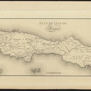
Map of Java divided into Dutch colonial administrative areas and the Mataram Sultanate (‘Pays de l'Empereur et du Sultan du Mataram entre melés [Country of the Emperor and the Sultan of Mataram mixed]’. The map is orientated with south at the top.
Plan de l'île de Java
eventc.1800-1820
location_onIndonesia
Map of Java divided into Dutch colonial administrative areas and the Mataram Sultanate (‘Pays de l'Empereur et du Sultan du Mataram entre melés [Country of the Emperor and the Sultan of Mataram mixed]’. The map is orientated with south at the top.