![](https://historicalmaps.yale-nus.edu.sg/rails/active_storage/representations/eyJfcmFpbHMiOnsibWVzc2FnZSI6IkJBaHBBaGdGIiwiZXhwIjpudWxsLCJwdXIiOiJibG9iX2lkIn19--463e8ab0457195504236516821ffbec9a1ff2806/eyJfcmFpbHMiOnsibWVzc2FnZSI6IkJBaDdCam9MY21WemFYcGxTU0lNTkRBd2VETXdNQVk2QmtWVSIsImV4cCI6bnVsbCwicHVyIjoidmFyaWF0aW9uIn19--bc467f5637e8b6d3bfb826116f92b6bfedfbf03a/nlb-B26056033C.jpeg)
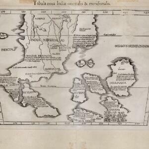
Tabula noua Indiæ orientalis & meridionalis
1541
Malaysia, Indonesia, Southeast Asia
This early map of Asia includes text describing the local people, their religious beliefs, crops, spices etc. On the island labelled Angama there is a drawing of anthropophagi—members of a mythical race of cannibals—chopping up a human body.