
Search Results


Carte des environs de Batavia = Kaart van de buitenstreeken van Batavia
c.1772-1780
Indonesia
This late 18th century map of Batavia (Jakarta) focusses on the network of canals and rivers surrounding the city, as well as the many fields and plantations, including rice fields (‘Champ de Ris’) and sugarcane (‘Cannes de Sucre’).
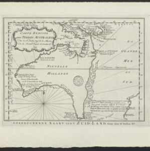
Carte Réduite des Terres Australes = Gereduceerde Kaart van 't Zuid-Land
1758
Indonesia, Papua New Guinea
New Guinea is shown connected to Australia (‘Nouvelle Hollande’) on this mid-18th century map. The title’s ‘Terres Australes’ means ‘southern lands’ indicating how Australia was named. The text is in French, with the title also in Dutch at the base.

Plan d'Amboine, tel qu'il étoit en 1718 = Platte-grond van Amboina, zoo als het was in den jaare 1718
c.1746-1770
Indonesia
This colourful mid-18th century plan of the city of Amboine (Ambon, capital of Ambon Island, in the Maluku Islands, Indonesia) has a detailed legend identifying locations within the city and the surrounding mountains. The text is in French and Dutch.
- Filter from 1746 to 1772
- Bellin, Jacques Nicolas4
- [remove]Schley, Jacobus van der4
- Prévost, Abbé3
- Du Bois, J.P.J.1


