Search Results

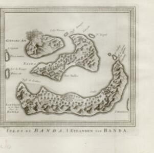
Isles de Banda = Eylanden van Banda
c.1772-1780
Indonesia
Map of the Banda Islands—which was at this time the only source of nutmeg in the world—featuring mountains, plantations, settlements and a military fort. On the island of Goenong Api (Banda Api) a volcano erupts (‘api’ means ‘fire’ in Indonesian).
- [remove]Mountain/Volcano2
- Jungle/Wooded Area1
- Bellin, Jacques Nicolas2
- Du Bois, J.P.J.2
- Prévost, Abbé2
- [remove]Schley, Jacobus van der2
- [remove]Amsterdam2


