Search Results

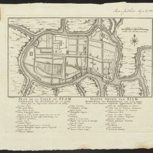
Plan de la Ville de Siam: Capitale du Royaume de ce nom = Platte grond van Siam: Hoofd stad des Koningryks van dien' naam
1687
Thailand
Map of the Siamese city of Ayutthaya (‘Ville de Siam’), surrounded by the Menam River (Chao Phraya River). Roads and buildings are marked, including a number of royal palaces and pagodas, which are listed on the Dutch and French-language legend.


