Search

Search Results

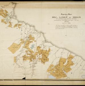
Figuratieve kaart van Deli, Langkat en Serdang met aanteekening der uitgegeven kontrakten

event1876

location_onIndonesia

Map of three regions on the northeast coast of Sumatra, with each region divided into parcels of land which are labelled with the name of a company. Presumably, these companies have been issued the contracts mentioned in the map’s title.

Kaart van de Adsistent Residentie Benkoelen: Middendeel

event1860

location_onIndonesia

Map of part of the Dutch colonial administrative region (assistant residency) of Benkoelen (Bengkulu, Sumatra). Inset map of Nias Island and the Batu Islands. (From ‘Algemeene Atlas van Nederlandsche Indie [General Atlas of the Dutch East Indies]’.)

Kaart van Celebes en Onderhoorigheden

event1858

location_onIndonesia

The 1825 route of the Dutch military officer Major Joseph le Bron de Vexela is marked on this hand-drawn and coloured map of the South Peninsula of Celebes (Sulawesi).

close

  • Filter from 1858 to 1876

Current results range from 1858 to 1876