A large-scale topographical map of the states of Hsipaw, Lawksawk and Mongkung, within the Shan State of Burma (Myanmar). Elevation is indicated by contour lines, and travel and trade routes, villages, areas of cultivation and markets are also shown.
Upper Burma
event1898
location_onMyanmar, Thailand
Map of Upper Burma divided into Divisions and Districts, and featuring the Irrawaddy and Chindwin rivers, the Burma State Railway, and settlements including the city of Mandalay.
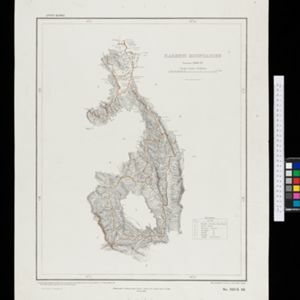
Karenni boundaries
event1898
location_onMyanmar
Map of the four Karenni States—Nammekon, Naungpale, Bawlake, Kyebogyi—in Burma (modern Kayah State, Myanmar) and surrounding areas. Mountains are represented by hachures: short lines/dashes that give a sense of the shape and steepness of terrain.